


|
||

|

|
|

|
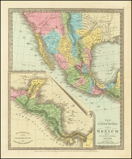
Scarce map of Texas, Upper California, Mexico, etc. from the first edition of David Burr's Universal Atlas.
While the map bears the copyright date of 1832, this example is published in 1836.
One of the earliest American maps to show Texas in its early Republic configuration. San Felipe de Austin, San Antonio, la Trinity, Nacogdoches, Ft. del Altar, Espada, Lagunilla, Matagorda, and Brazoria all appear within the boundary of Texas.
In California, the R. de los Martires is shown, an apocryphal river running from San Luis Rey in North San Diego County to Southern Utah, more or less parallel to the Rio Colorado. The mouth of the Gila is in the Gulf of California. The Missions of Upper California are shown.
Akropolis or Little Rock is identified, as are Taos, Santa Fe and Paseo del Norte on the Rio Grande. Nice large inset of Guatemala or the United Provinces of Central America.
Burr's map of Texas, first issued in 1833, is one of the seminal Texas maps. This map, issued several years later, draws from Burr's early information on Texas.
David H. Burr studied law, passing the New York Bar Exam, and then surveying under Simeon DeWitt in New York. His first atlas was an atlas of New York State (1829), the second state atlas to be issued in the US (after Mills’ Atlas of South Carolina in 1826). In the 1830s, he served as the official topographer for the US Post Office, producing a series of rare and highly sought-after large-format state maps. He also created a map of the country’s postal routes, which features roads, canals, and railroads. Burr traveled to London to work with John Arrowsmith; together, they produced the American Atlas in 1839.
Upon his return to the States, Burr was appointed as a draftsman for the House of Representatives, where he worked until ca. 1841. He later worked for the Louisiana Survey and the Florida Survey. By 1850, he was back in Washington D. C., working on the census. In 1852, the Senate named Burr as the draftsman to compile maps from the Federal Surveys. In 1853, Burr traveled to San Francisco, perhaps as part of his work for the Senate. He was then named as the Surveyor General of Utah in 1855. However, he was unpopular there and returned to Washington D. C. by 1870. Burr is widely regarded as one of the most important names in the nineteenth-century American history of cartography.
![[Mexico and Central America with Baja California inset, from Generalkarte von Nord America samt den Westindischen Inseln Versasst von Herrn. Pownall . . . MDCCLXXXVIII]](https://storage.googleapis.com/raremaps/img/small/95064.jpg)
![[Acapulco] Haven van Aquapulco in t' Coninkryk van Nova Spagnien in de Zuyd Zee](https://storage.googleapis.com/raremaps/img/small/91246.jpg)