|
||

|

|
|

|
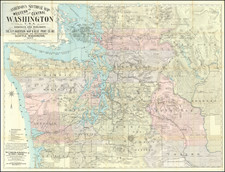
The Best Map of Western Washington From the 19th Century
Rare large format map of the western part of Washington Territory, the earliest separately issued large format map of Washington Territory.
The map is colored by counties and highlights the rugged topography of the western part of the Washington Territory at the beginning of its boom years. Seattle is a tiny settlement south of Union Lake, with a "Saw Mill" noted across Elliott Bay and Akili Point. Tacoma is also showng as an even smaller town, with a neighboring saw mill, 3 years before it was selected as the terminus of the Northern Pacific Railroad (over Seattle).
The map includes extensive soundings and coastla features, beginning in the Strait of San Juan de Fuca. San Juan Island is named, with an area of Prairie land identified in green. Ft. Bellingham, Whatcome and the Coal mines at the mouth of the Whatcome River are shown. Near Port Townsend, Marrowstone Island is also alternatively identified as Pt. Ringgold, named for Captain Cadwalader Ringgold, a crew member aboard the Wilkes expedition who would go on to create the first set of Sea Charts of the area around San Francisco Bay in 1850.
According to text on the map, Colton based this early commercial map of Washington Territory on U.S. surveys by Charles A. White. White's map is a masterwork of topographical detail, at a time when no other map of Washington had been attempted on such a large scale. The extent of the General Land Office Township Surveys can be seen, along with towns, roads, forts, rivers, Government Reserves, Indian Reservations and a host of other cartographic details.
The color code denotes:
- Prairie Lands (Green)
- Government Reserves (Red)
- Indian Reservations (Blue)
The Library of Congress catalog entry attribute the map to Charles Abiathar White (1826-1910), the U.S. geologist who served as state geologist of Iowa and later participated in U.S. Geological Surveys in the West.
Rarity
The map is extremely rare. OCLC locates no copies of the map in any institutional collections, although the map appears in the collections of Yale (Beinecke) and Library of Congress. The earliest separate map of Washington Territory listed by OCLC was published in 1880.
![[ Northern Pacific Railroad ] NEW 7-30 GOLD LOAN OF THE Northern Pacific Railroad Co. SECURED BY FIRST MORTGAGE ON RAILROAD AND LAND GRANT. SAFE! PROFITABLE! PERMANENT!](https://storage.googleapis.com/raremaps/img/small/101828.jpg)

![[ Pacific Coast Pictorial Road Maps ] Scenic Touring Scout](https://storage.googleapis.com/raremaps/img/small/101745.jpg)