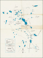
|
||

|

|
|

|
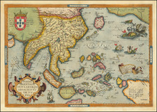
Fine example of Johannes Van Loons' sea chart of the Pacific Ocean, extending from Australia, New Zealand and Japan to California.
Van Loon's chart is among the earliest regioal maps to focus on the Dutch discoveries in New Zealand and Australia. Van Diemen's explorations in Australia of 1642 are noted and dated, as is a note regarding the discovery of New Zealand in 1642. The prospect that Australia and New Guinea are not connected is rather vaguely depicted by Goos, making it one of the earliest sea charts to recognize this passage. Many other islands are noted, as is Japan, with a curious depiction of its northern islands.
Across the Pacific Ocean, Californai and the Straits of Anian are plainly depicted.
Rarity
Van Loon's sea atlas is among the rarest of all sea atlases from the Golden Age of Dutch Cartography. This is the first time we have ever offered the map for sale.
![[The Spanish fleet in the Ladrone Islands]](https://storage.googleapis.com/raremaps/img/small/48713.jpg)