![(Carolinas) Virginiae Partis australis, et Floridae partis orientalis, interjacentiumqus regionum Nova Descriptio [A New Description of the Southern Part of Virginia and the Eastern Part of Florida, and the Intervening Regions.] By Jan Jansson](https://storage.googleapis.com/raremaps/img/small/94131.jpg)


|
||

|

|
|

|
Nice example of this scarce late 17th Century map of the Southeast.
Valk & Schenk's map is a rare re-issue and reworking of Jan Jansson's map of the region.
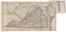
Jansson's map of the Carolinas and Blaeu's map of the Carolinas are virtually indistinguishable cartographically, although there are a number of minor differences in the embellishments. Both maps are on the larger 1606 Mercator-Hondius map of the Carolinas but with significant improvements. The map covers an area from the mouth of the Chesapeake Bay to Georgia and reflects the competing interests of France and England in the New World, with the coat of arms of each country identifying the regional control. As noted by Burden, the French claims are supported primarily by the French colonization efforts of the 1560s.
As noted by Burden,
The greatest improvement occurs in the northern half of the map north of Porto Royal. Whereas on the Hondius [map] the coastline towards C. de. Ste. Romano (present day Cape Fear) veered directly east, Blaeu more correctly takes it north-east, placing the cape closer to its true position of 34 degrees. This span of coastline is approximately that of present day South Carolina. This now presents to us a more accurately proportioned Outer Banks region, radically reduced in size but still slightly too far north. For these improvements, Blaeu drew upon the extremely rare DE EYLANDEN . . . by Hessel Gerritsz., c. 1631. The Outer Banks combine the placenames of Gerritsz and Hondius, often using two different ones for the same area . . .
Chesapeake Bay was depicted just as a small bay on Hondius' map of 1606, as John Smith was yet to explore these waters. The Gerritsz terminated at this point, and only two placenames appeared. Blaeu draws largely on Smith's map for much of the nomenclature, but introduces some English [names] from an unknown source. The most important is Newport News. Newport News, founded in 1621 and apparently shown here for the first time on a printed map. Also new are Bermouth, Stortingen and Arglas . . .
Includes the marvelous mythical lakes in the interior and other conjectural cartography of the time.
Includes a large cartouche, 2 coats of arms, 2 compass roses and several sailing ships.
Peter Schenk the Elder (1660-1711) moved to Amsterdam in 1675 and began to learn the art of mezzotint. In 1694 he bought some of the copperplate stock of the mapmaker Johannes Janssonius, which allowed him to specialize in the engraving and printing of maps and prints. He split his time between his Amsterdam shop and Leipzig and also sold a considerable volume of materials to London.
Peter Schenk the Elder had three sons. Peter the Younger carried on his father’s business in Leipzig while the other two, Leonard and Jan, worked in Amsterdam. Leonard engraved several maps and also carried on his father’s relationship with engraving plates for the Amsterdam edition of the Histoire de l'Académie Royale des Sciences.
Gerard Valk, or Gerrit Leendertsz Valck (1652-1726) together with his son Leonard, were the only significant publishers of globes in the Netherlands in the eighteenth century, enjoying an almost total monopoly in the first half of the 1700's. Initially an engraver and art dealer, and having worked for map-sellers Christopher Browne and David Loggan in London between 1672 and 1679, Valk established the firm in Amsterdam in 1687. Initially, they published maps and atlases, but in 1700 the company moved the shop to the building previously occupied by map and globe-maker Jodocus Hondius. In 1701, he applied for a charter for making globes and the "Planetolabium", designed by Lotharius Zumbach de Coesfelt (1661-1727), an astronomy lecturer at Leiden University. The Valks produced several editions of 3, 6, 9, 12, 15, 18 and 24-inch diameter terrestrial and celestial globes. The cartography, as stated on the cartouche, is based closely on the celestial atlas Uranographia, published in 1687 by the celebrated Polish astronomer Johannes Hevelius (1611-1687).
Around 1711, when he became a member of the bookseller's guild, Leonard Valk (1675-1746) came into partnership and his name started to appear alongside that of his father on the cartouches of the globes, although the earliest of these, both terrestrial and celestial, still bear the date 1700. Leonard naturally took over the business on his father's death in 1726, and following his own death in 1746 the firm was run by Maria Valk, cousin, and wife to Gerard. By then its days of glory had passed. Leonard Valk died in relative poverty: his wife had to take in the washing of their aunt to make ends meet. The late eighteenth century saw a number of successful reissues by publisher Cornelis Covens (1764-1825), who ran the famous cartographical publishing house of Covens & Mortier (1721-1866) in Amsterdam. This firm was the biggest Dutch one for publishing maps in the 18th century. It was located on the Vijgendam (Fig Dam), the southern part of what is now Dam Square, the central hub of the city. They didn't move out of their building, but they did change addresses. At first in 1795 the whole Dam was rebaptized into Revolution Square, then it got the name Napoleon Square, till in 1813 after Napoleon's fall Covens & Mortier were back again at the Vijgendam.