


|
||

|

|
|

|
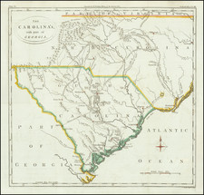
An Impressive Early 19th Century Map of The Southeast including Spanish East & West Florida
Fine example of the first edition of Cary's map of the Southern United States and Bahama Islands, extending the East Coast to the Mississippi River and from Tennessee and the Carolinas to Florida, the Bahamas and the Gulf Coast.
One of the most interesting features of the map is the location of East Florida and West Florida, shortly before the creation of the so-called Republic of West Florida in 1810 (see more below).
A massive Georgia extends from the Atlantic to the Mississippi River, as it existed immediately prior to the creation of Mississippi Territory (created in 1798, but not widely depicted on maps for another decade). Many remarkable notes are present, including the hunting grounds of the Western Party and Six Villages along the Mississippi and the Eastern Party due east thereof, between the Yasoo and Tombechbe Rivers, notes regarding the destruction of Chatchioomas and Fort Francois in 1736 and 1729 respectively, and a host of other interesting notes in Western Georgia. The region controlled by the Chickasaws and Upper Creeks names dozens of villages and other places and includes early roads. The Cherokee region is also well depicted. Many roads are shown in the Carolinas and some in Tennessee as well. Many early forts are depicted.
The map provides an excellent treatment of East and West Florida, the latter of which was still under Spanish control until 1812, although claimed as part of the Louisiana Purchase in 1803. In Florida, Fort St. Marks, Apalacha Fort, and the roads across from St. Augustin are shown, with a note that the Apalachees Villages are now deserted. Southern Florida is Ancient Tegesta and The Promontory. A Lake and River system connects Mayaco Lake with the St. Johns River.
Spanish West Florida and the Republic of West Florida
In 1783, th Brisith ceded both East Florida and West Florida provinces back to Spain. Spain continued to maintain East and West Florida as separate colonies.
In the secret Treaty of San Ildefonso of 1800, Spain agreed to return Louisiana to France; however, the boundaries were not explicitly specified. After France sold the Louisiana Purchase to the United States in 1803, another boundary dispute erupted. The United States laid claim to the territory from the Perdido River to the Mississippi River, which the Americans believed had been a part of the old province of Louisiana when the French had agreed to cede it to Spain in 1762. The Spanish insisted that they had administered that portion as the province of West Florida and that it was not part of the territory restored to France by Charles IV in 1802, as France had never given West Florida back to Spain, among other reasons.
The United States and Spain held long, inconclusive negotiations on the status of West Florida. In the meantime, American settlers established a foothold in the area and resisted Spanish control. British settlers, who had remained, also resented Spanish rule, leading to a rebellion in 1810 and the establishment for 74 days of the Republic of West Florida. Early in the morning on September 23, 1810, armed rebels stormed Fort San Carlos at Baton Rouge and killed two Spanish soldiers. The rebels unfurled the flag of the new republic, a single white star on a blue field. After the successful attack, organized by Philemon Thomas, plans were made to take Mobile and Pensacola from the Spanish and incorporate the eastern part of the province into the new republic. Reuben Kemper led a small force in an attempt to capture Mobile, but the expedition ended in failure.
Support for the revolt was far from unanimous. The faction that favored the continued independence of West Florida secured the adoption of a constitution at a convention in October. The convention had earlier commissioned an army under General Philemon Thomas to march across the territory, subdue opposition to the insurrection, and seek to secure as much Spanish-held territory as possible. Thomas' army violently suppressed opponents of the revolt.
During this period, on October 27,1810, President James Madison proclaimed that the eastern portion of West Florida was part of the US under the Louisiana Purchase.
On November 7, Fulwar Skipwith was elected as governor, together with members of a bicameral legislature. Skipwith was inaugurated on November 29. A week later, he and many of his fellow officials still lingered at St Francisville preparing to go to Baton Rouge, where the next session of the legislature was to consider his ambitious program. The impending U.S. takeover apparently came as a surprise to Skipwith when the Mississippi Territory governor, David Holmes, and his party approached the town. Holmes persuaded all except a few leaders, including Skipwith and Philemon Thomas, the general of the West Florida troops, to acquiesce to American authority.
Skipwith complained bitterly to Holmes that, as a result of seven years of U.S. tolerance of continued Spanish occupation, the United States had abandoned its right to the country and that the West Florida people would not now submit to the American government without conditions. Skipwith and several of his unreconciled legislators then departed for the fort at Baton Rouge, rather than surrender the country unconditionally and without terms.
Following Madison's proclamation, Orleans Territory governor William Clairborne was sent to the area, taking possession in December 1810. At Baton Rouge on December 9, Skipwith informed Holmes that he would no longer resist but could not speak for the troops in the fort. Their commander was John Ballinger, who upon the assurance of Holmes that his troops would not be harmed, agreed to surrender the fort. The Orleans Territory governor, William C. C. Claiborne and his armed forces from Fort Adams landed two miles above the town and the flag of West Florida was lowered for the last time.
On February 12, 1812, Congress authorized the taking of the rest of West Florida.
The Spanish continued to dispute the annexation of the western parts of its West Florida colony, but their power in the region was too weak to do anything about it. They continued administering the remainder of the colony (between the Perdido and Suwannee Rivers) from the capital at Pensacola until the Adams-Onis Treaty was signed in February 1819, transferring the area to the US and ending Spain's claims to regions in the southeastern part of North America.
John Cary (1755-1835) was a British cartographer and publisher best known for his clean engraving and distinct style which influenced the entire map industry. Born in Wiltshire, John was apprenticed to an engraver in London. He started his own business by 1782 and moved to several premises before settling at 86 St James’s Street in 1820.
Cary had several significant collaborations during his career. John Wallis and Cary diversified Cary’s business to include broader publishing projects. Brother William and John made globes together, while brother Francis participated in the company’s engraving work. Finally, geologist William Smith and Cary developed and sold geological maps, some of the first of their kind. The pair also produced a notable series of county maps starting in 1819. Cary’s atlases, of English counties and the world, were the standard texts of the early nineteenth century. He was appointed surveyor of roads to the General Post Office in 1794, which led to the New Itinerary, first published in 1798.
John trained his son, George, in engraving and George and his other son, John Jr., took over the business in 1821. It was then known as G. and J. Cary and continued in trade until 1850. The firm’s materials were then acquired by George Frederick Cruchley and then Gall and Inglis. By the time John died in 1835, Cary was the authoritative name in private map publishing and his business was a leader in the field throughout the first half of the nineteenth century.
![Carta geografica della Florida nell'America settentrionale [Geographical map of Florida in North America]](https://storage.googleapis.com/raremaps/img/small/84142.jpg)
![[ Florida Native Americans ] Mulierum, quarum maritivel in bello caesi, aut morbo sublati posulata a Rege. XVIII.](https://storage.googleapis.com/raremaps/img/small/98052.jpg)
