|
||

|

|
|

|
First English Edition of Jefferson's Notes on Virginia, with the Only Map Attributed to Thomas Jefferson.
Thomas Jefferson's iconic book had its roots in a questionnaire that was circulated by Francois Barbé-Marbois, a French diplomat stationed in Philadelphia. After serving as Governor of Virginia from 1779 to June 1781, Jefferson began writing his response to Barbé-Marbois. While serving as United States Ambassador to France, in Paris, Jefferson had his response privately printed for a close circle of friends. The text was deemed useful for a wider audience, consequently Jefferson gave his blessing to this regular published edition, which appeared in 1787.
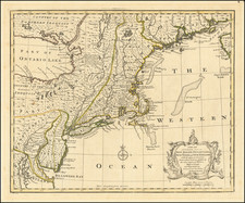
Jefferson's Map
This is the first English language edition to include Jefferson's famous map, as the private edition issued in Paris did not have a map. The plate for this map has an interesting history as the same plate was used to make the impressions for both the first French edition of Notes as well as the present first regular English edition. It was originally engraved by Samuel Neele in London, then corrected per Jefferson's instructions by the Paris engraver Guillaume Delahaye. After Jefferson had arranged with the London publisher John Stockdale to publish this regular English edition he had the plate forwarded to Stockdale who added his imprint to the plate.
The present example of the map bears the London publisher's imprint in the lower left corner, below the neatline, as proper for the first regular English edition of the text: Published as the Act directs July 13th 1787 by John Stockdale in Piccadilly.
A MAP of the country between ALBEMARLE SOUND, and LAKE ERIE, comprehending the whole of VIRGINIA, MARYLAND, DELAWARE, and PENSYLVANIA, with parts of several other of the United States of America. ____ Engraved for the Notes on Virginia.
Unusually, the map is subtitled with a description of its sources:
The country on the eastern side of the Allegany Mountains, is taken from Fry and Jefferson's Map of Virginia, and Scull's Map of Pennsylvania, which were constructed chiefly on actual survey; that on the western side of the Allegany, is taken from Hutchins, who went over the principal water courses, with a compass and log-line, correcting work by observations of latitude: additions have been made, where they could be made on sure ground.
The additions referred to in the last line of the caption seem to have been made by Jefferson himself, leading to the map being the only map attributed to Jefferson.
The key in the lower right differentiates towns, forts, courthouses, churches, private dwellings, county lines, and lines dividing states.
It is likely that this map is the source of all other references to Frankland and Franklinia to appear on maps, as there are no other maps published in America which include this ephemeral name for this region. Jefferson apparently intended to add county names but was unable to procure a copy of John Henry's scarce map of Virginia. Jefferson arranged with Samuel J. Neele in September 1786 to have the map engraved.