|
||

|

|
|

|
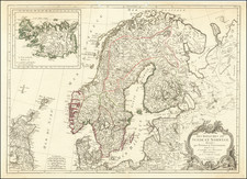
Nice old color example of Waldseemuller's map of Eastern Europe, extending from the Black Sea to Scandinavia and the Baltic Regions, centered on Russia and the Ukraine.
The map includes a number of written notes in a contemporary hand.
The map is drawn from the work of Claudius Ptolemy, as interpreted by Martin Waldseemuller, one of the most important mapmakers of the first half of the 16th Century. Waldseemuller's edition of Ptolemy's Atlas has been termed "the first modern atlas," because the 20 new maps show all parts of the world based on contemporary knowledge .
Martin Waldseemuller of St. Die in France began work on his new edition of Ptolemy in 1505. At the time, he was one of the most important of all mapmakers and cosmographers, and his map of the World would become the first map to name America. His new edition of Ptolemy was the first published in the 16th Century and is among the most important and sought after of all editions of Ptolemy's work.
Martin Waldseemüller (c. 1475-1520) was a sixteenth-century cosmographer best known for his 1507 world map in twelve sheets, the earliest surviving map to include the name “America.” He was an influential mapmaker during his time whose work affected many of his contemporaries and successors. Waldseemüller was born near Freiburg, in what is now southwestern Germany. His family moved to Freiburg proper when he was young and he attended university in the city beginning in 1490.
Waldseemüller gathered information about the New World discoveries and geography from St.-Dié des Vosges in Lorraine, where he was a professor of cosmography under the patronage of René II, Duke of Lorraine. He was a member of an intellectual circle who produced work from the St.-Dié Press. However, the press failed when the Duke died, and Waldseemüller moved to Strasbourg.
He is best known for the 1507 map and another world projection, the Carta Marina published in 1516. He also published an edition of Ptolemy in 1513, in collaboration with Johann Schott, a friend from Freiburg and St.-Dié. Besides his innovative use of the toponym “America”, Waldseemüller was the first to create such a large printed world map, the author of the earliest known printed globe gores, the first to create a published collection of modern maps, and one of the first to create maps from ground measurements. He was knowledgeable in surveying methods and designed a quadrant and other instruments. He returned to St.-Dié late in life as canon, although he continued to return to Strasbourg for work and for carnival. He died in St.-Dié in 1520.
Waldseemuller is generally credited with having named the continent of America, based upon the then current belief that Amerigo Vespucci had been the first modern explorer to reach the continent of America in 1497, during the first of four expeditions to America which were then credited to Vespucci between 1497 and 1504. The report which described the 1497 expedition is now generally believed to be a forgery. Later in his career, Waldseemüller elected not to use the toponym for the continents, preferring to leave them unnamed. However, the name had been taken up by his contemporaries, in large part due to the influential nature of Waldseemüller’s earlier works.

![Europae Tabula VIII [Russia, Ukraine, Baltic, Scandinavia]](https://storage.googleapis.com/raremaps/img/small/86526.jpg)