|
||

|

|
|

|
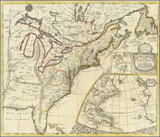
The First State of the First Dutch Map of Virginia
First state of Jodocus Hondius's map of Virginia and the Chesapeake region, based upon Captain John Smith's map of Virginia, the most important map of Virginia published in the 17th century.
This is rare first state of Hondius' rare separately issued map, first engraved by Jodocus Hondius in 1618 and later purchased by Blaeu following Hondius' death in 1629. Engraved by Dirk Grijp for Jodocus Hondius Jr. in 1618, the map was not used in any recognized atlas.
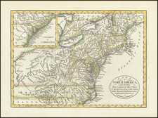
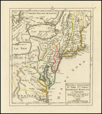
The map depicts the discoveries in the region detailed by John Smith in his seminal map of Virginia, first issued in 1612. Because of the commercial success of Blaeu's Atlases, it is Blaeu's map of Virginia which influenced 2 generations of European map makers regarding the English mapping and discoveries in the region. It was the primary influence on other maps of the period and the standard map of the region until Augustine Hermanns map of 1673.
In 1606, the London Company sent its first ship to Virginia and established the Jamestown settlement. Captain John Smith accompanied the English settlers at Jamestown. Between 1607 and 1609, he explored the major rivers which flowed west into the Chesapeake Bay, recording the names of the Native American villages and tribes he encountered. The limits of Smith's explorations are marked with a Maltese cross, which Blaeu incorporates on his map and can typically be seen at the upper part of each of the rivers depicted on Blaeu's map. Beyond the crosses, Smith relied on Native American accounts to delineate territories further upriver. Smith notes on the map "To the crosses hath bin discouerd what beyond is by relation."
Upon Smith's return to England in 1609, Smith employed William Hole to engrave a map, which was first included in a small pamphlet by Joseph Barnes of Oxford in 1612. Jodocus Hondius engraved the first edition of this map in 1618, making it the second appearance of Smith's original manuscript to appear in print. Smith's original map would not appear again until 1624, when it was included, along with Smith's map of New England, in his landmark work, The Generall Historie of Virginia, New-England, and the Summer Isles, in 1624. The following year it was included in Purchas His Pilgrimes.
There is some question as to whether the map is the work of Smith, who led most of the explorations, or the surveyor accompanying him, Nathaniel Powell. The original Smith map can be viewed here: /gallery/detail/23677
An essential map for collectors of this region.
Rarity
The map is very rare on the market. The last appearance in a dealer catalog was Jonathan Potter, Catalog 325 (2002), Item #242 ($11,200). This is the first example of the map we have offered in over 25 years.
Provenance: Colonial Williamsburg
Jodocus Hondius the Elder (1563-1612), or Joost de Hondt, was one of the most prominent geographers and engravers of his time. His work did much to establish Amsterdam as the center of cartographic publishing in the seventeenth century. Born in Wakken but raised in Ghent, the young Jodocus worked as an engraver, instrument maker, and globe maker.
Hondius moved to London in 1584, fleeing religious persecution in Flanders. There, he worked for Richard Hakluyt and Edward Wright, among others. Hondius also engraved the globe gores for Emery Molyneux’s pair of globes in 1592; Wright plotted the coastlines. His engraving and nautical painting skills introduced him to an elite group of geographic knowledge seekers and producers, including the navigators Drake, Thomas Cavendish, and Walter Raleigh, as well as engravers like Theodor De Bry and Augustine Ryther. This network gave Hondius access to manuscript charts and descriptions which he then translated into engraved maps.
In 1593 Hondius returned to Amsterdam, where he lived for the rest of his life. Hondius worked in partnership with Cornelis Claesz, a publisher, and maintained his ties to contacts in Europe and England. For example, from 1605 to 1610, Hondius engraved the plates for John Speed’s Theatre of the Empire of Great Britaine.
One of Hondius’ most successful commercial ventures was the reprinting of Mercator’s atlas. When he acquired the Mercator plates, he added 36 maps, many engraved by him, and released the atlas under Mercator’s name, helping to solidify Mercator’s reputation posthumously. Hondius died in 1612, at only 48 years of age, after which time his son of the same name and another son, Henricus, took over the business, including the reissuing of the Mercator atlas. After 1633, Hondius the Elder’s son-in-law, Johannes Janssonius, was also listed as a co-publisher for the atlas.