This item has been sold, but you can enter your email address to be notified if another example becomes available.


|
||

|

|
|

|
Stock# 54451
Description
Rare separately published map of Buenos Aires by H. Montheil, published in February 1898.
The map locates railroads, rural trams, public buildings and Plaza.
The map was published during a period of tremendous growth in Buenos Aires and Argentina.
During most of the 19th century, the political status of the city remained a sensitive subject. It was already the capital of Buenos Aires Province, and between 1853 and 1860 it was the capital of the seceded State of Buenos Aires. The issue was fought out more than once on the battlefield, until the matter was finally settled in 1880 when the city was federalized and became the seat of government, with its mayor appointed by the president. The Casa Rosada became the seat of the president.
Condition Description
Dissected and laid on linen. Folding into original covers.
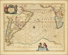
![[ Patagonia / Chile / Argentina ] A New Map of the Southern Parts of America taken from Manuscript Maps made in the Country and a Survey of the Eastern Coast made by Order of the King of Spain.](https://storage.googleapis.com/raremaps/img/small/100772.jpg)

![ПОЛИТИЧЕСКАЯ КАРТА ЮЖНОЙ АМЕРИКИ. [Political Map of South America]](https://storage.googleapis.com/raremaps/img/small/90259.jpg)