|
||

|

|
|

|
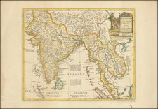
An Important Early Map of the Kangchenjunga Glaciers
Important early mapping of the Glaciers of Kangchenjunga' by Edmund Johnston Garwood was prepared during the Freshfield expedition of 1899.
The route of the expedition is shown with a red line in red line. In lead pencil "Capt Bousteads route from May 1926" has been added to the map, a reference to Sir John Edmond Hugt Boustead (1895-1980), a British military officer, mountaineer, explorer and diplomat participated in both the 1926 British expedition to Kangchenjunga and the 1933 expedition to Mount Everest.
The map significantly improves upon the best maps of the Survey of India. Greater importance was attached to the representation of mountain features, as Freshfield pushed forward on all sides towards Kangchenjunga. Garwood visited a large number of high points, which are distributed throughout the area, and made a rapid survey from them. He also took several photographs.
The map provides a fine topographical overview of the main mountain ridges and drainage. The glaciers, including the side ones, are depicted with particular care and are accurately mapped in position and size; their features, such as moraines and crevasses, are shown; and although the map is somewhat lacking as regards being an exact representation of the ground-e.g. it contains only rough shading and no contours-yet it will always be a good example of what a general map should be, and in many respects even now it can serve as a model for methods of survey and representation of features. It has proved itself complete and reliable in the Zemu area within the limits prescribed for it.
Kangchenjunga is the third highest mountain in the world, and lies partly in Nepal and partly in Sikkim, India. The elevation is 28,169 ft. The mountain is located about 78 miles east-south-east of Mount Everest. Kangchenjunga is the second highest mountain of the Himalayas. Kangchenjunga Main is the highest mountain in India and until 1852, Kangchenjunga was assumed to be the highest mountain in the world, but calculations based on various readings and measurements made by the Great Trigonometrical Survey of India in 1849 came to the conclusion that Mount Everest, known as Peak XV at the time, was the highest.
Kangchenjunga was first climbed on May 25, 1955 by Joe Brown and George Band, who were part of a British expedition. .
The annotations at the bottom of the map include the following note:
Pencilled Capt Bousted's Route May 1926 . . .
Edmund Johnston Garwood
Edmund Johnston Garwood (1864-1949) was a British geologist and President of the Geological Society of London from 1930 to 1932. The following is excepted from Biographical Memoirs of the Fellows of the Royal Society
Besides being an excellent climber, Garwood was an ardent and skilful photographer. With these two qualifications he was asked by his friend, Dr Douglas Freshfield, to join his expedition to the Sikkim Himalayas in 1899. Garwood's first duty was to visit Sig. Sella at Biella and persuade him to join the party as official photographer. This he did and, being thus relieved of the duties of official photographer, was able to devote himself to climbing and making a topographical map of the Kangchenjunga glaciers. This map, together with notes on the physical features and geology, is published in Freshfield's book Round Kangchenjunga (1903). The party came in for some very rough weather, and when at Darjeeling 24 inches of rain fell in twenty-six hours the expedition was thought to have come to grief-so much so that obituary notices were published! When in 1930 Dr Dyrenfurth led an expedition to the same area, he recorded that he had found Garwood's map amazingly accurate and still recognized by the Survey of India as being the most reliable one of that locality-a compliment that greatly pleased Garwood.
It was during the time spent in the Himalayas that Garwood crystallized his ideas regarding glacial erosion in mountainous areas. He had first-hand knowledge of much of the Alps, of Spitzbergen, and now of Sikkim. He was more impressed by the obvious great erosion caused by the streams flowing from the glacier snouts than by the ice itself where it rested in an upland valley. He therefore became one of the staunch supporters of the protection theory of Alpine valley erosion, according to which the chief erosive agent was running water and the ice itself protected the floor on which it was lying more or less inert. Naturally he allowed the ice to widen the valley and do some erosion, but the main deepening he claimed was due to water erosion. This view was developed in his papers published in the Quarterly Journal of the Geological Society, 1902, and in the Geographical Journal for 1910, but was not accepted by many glaciologists at the time, perhaps because of the rather complex series of glacier advances and retreats which the theory involved. In general, however, Garwood's views, somewhat modified, have been accepted as holding much truth.
Shortly after his return from Sikkim, Dr T. G. Bonney retired from the chair of geology at University College, London, and Garwood was appointed to the Yates-Goldsmid Chair in 1901, a position which he held till he retired in 1931.