|
||

|

|
|

|
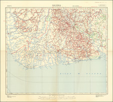
Rare Early Transportation Map of the French African Colonie of Dahomey (Benin).
The map includes a legend that identifies:
- Automobile Routes
- Auto routes under construction
- Principal non-automobile roads
- Railroads
- Railroads under construciton
- Mixed Communes
- Places with Post service, Telegraph and Telephone
- Places with Post service, Telegraph or Telephone
- Radion stations
French Dahomey was a French colony in French West Africa from 1904 to 1958. After World War II, by the establishment of the French Fourth Republic in 1947, Dahomey became part of the French Union and was given greater autonomy. On December 11,1958, the French Fifth Republic was established and the French Union became the French Community. The colony became the self-governing Republic of Dahomey within the Community, and two years later on August 1, 1960 it gained full independence, changing its name to Benin in 1975.
Rarity
The map is very rare. We locate examples at the British Library, BnF, New York Public Library and University of Leiden.
![(South Atlantic) Nieuwe Wassende Graadige Pas-kaart van de Kust van Guinea en Brasilia strekkende van Cap Verde tot de Cap de Bon-Esperance en Verders van Rio de Berbice tot Rio de la Plata. [New Increasing Latitude Sea Chart of the Coast of Guinea and Brazil stretching from Cape Verde to the Cape of Good Hope and Further from the Berbice River to the Rio de la Plata.]](https://storage.googleapis.com/raremaps/img/small/99819.jpg)
![[ Canary Islands and Madeira Islands ] Isola di Canarie. . [with] Isola Madeira](https://storage.googleapis.com/raremaps/img/small/98646.jpg)
![[The First Maps Printed Color] Cartes en Couleur des Lieux Sujets aux tremblements de Terre Dans toutes les parties du Monde Selon le Sisteme de l’impulsion Solaire](https://storage.googleapis.com/raremaps/img/small/52293op.jpg)