
This item has been sold, but you can enter your email address to be notified if another example becomes available.


|
||

|

|
|

|
Stock# 53641
Description
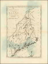
One of the earliest obtainable American Maps of Massachusetts
Scarce map of the Commonwealth of Massachusetts, published shortly after the conclusion of the American Revolution.
A detailed map Massachusetts, with Berkshire and Hampshire counties appearing in a large inset.
Includes towns, roads, islands, rivers and some topographical features.
Reference
Wheat & Brun: 218

![Carte Reduite Des Costes Orientales De L'Amerique Septentrionale . . . contenant L'Isle Royale . . . La Nouvelle Angleterre et la Nouvelle Yorc . . . MDCCLVII [with Plan of Boston Harbor] Plan du Havre de Baston](https://storage.googleapis.com/raremaps/img/small/80006.jpg)

![[French & Indian War] Carte Des Possessions Francoises et Angloises dans le Canada et Partie de la Louisiane . . . 1756](https://storage.googleapis.com/raremaps/img/small/94026.jpg)
