|
||

|

|
|

|
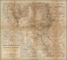
A striking example of a map which rarely appears in such nice condition. Only 5 counties are shown in Arizona (Mohave, Yuma, Pima, Maricopa and Yavapai) and 14 in New Mexico. Two roads traverse the region Yuma to El Paso and the Atlantic & Pacific RR, with the Denver & Rio Grande the only North-South route shown. Arizona is dominated by early forts, Indian Villages and early mining towns. Phoenix makes an early appearance in Arizona. New Mexico also shows many Forts, Indian Villages and Mountain Ranges. The Santa Fe and Kansas & Pacific Routes are also shown. A fine early map, one of the best commercial atlas maps of the region in the 1870s.
O. W. Gray was a publishing firm based in Philadelphia. Later, they published as O. W. Gray & Son. They published atlases in the late nineteenth century. Gray's National Atlas was one of the most successful commercial ventures of the 1870s and one of the last to employ hand coloring on maps.