|
||

|

|
|

|
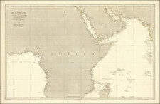
Sanson’s Map of South and Southeast Asia
Fine example of this important early map of India and Southeast Asia by France’s premier mapmaker, Nicolas Sanson.
The map stretches from Gujarat in the east to China in the west, showing island and archipelagos like the Maldives, Andamans, Sri Lanka, Sumatra, and part of Borneo. The map stresses the importance of the fertile Ganges River Delta and of the political divisions of the area.
Overall, its coverage shows much of the area that interested European traders eager to access Indian and Southeast Asian resources and commercial networks in the early modern period.
Initially published in 1654 as a separately-issued map, it was later included in Sanson's atlas, Les Cartes Générales de toutes parties du Monde, first issued in 1658. The map was engraved by Jan van Somer.
The Dutch and English East India Companies and the Indian Ocean World in the seventeenth century
Seventy years before this map was published, the Dutch (1602) and English (1600) East India Companies were founded in order to trade directly with the Indian subcontinent. They followed Portuguese traders who had set up trading forts on the subcontinent. They also relayed trade from the lucrative Spice Islands in southwest Asia. Both companies operated a monopoly over trade and gained immense power.
By 1700, the Dutch and English were joined by the French and Danish East India Companies, but the English were by far the strongest presence in Asia at that time. Eventually, during the century after the publication of this map, the lines between commercial and political dominance became increasingly blurred. The English East India Company's control of the seas, greater resources, and more advanced military training and technology led it to become attractive to a portion of the Indian elite. These factors were crucial in allowing the Company to gain control over the Bengal region by 1765 and to sideline other European countries. India later became a British colony.
The Maldives, to the east of India, had long been coveted as a valuable port and they held importance due to their central location within the Indian Ocean, half way between Africa and the Straits of Malacca. The Portuguese were the first Europeans to come, in 1558, but they were resisted by the mostly Islamic population. The Dutch came next, in the mid-seventeenth century, but they only ensured their access to ports and watering; they did not involve themselves in local affairs. Long after this map was published, in 1796, the British took the Maldives from the Dutch and it became a protectorate in 1887.
The colonial fate of the Maldives was tied to that of Ceylon, which is now known as Sri Lanka. Like the Maldives, the Portuguese were the first Europeans to arrive, in 1505. They built a fort and extended their rule over the island, despite intense Indigenous resistance and the survival of the independent Kingdom of Kandy. In 1638, the Dutch East India Company (VOC) signed a treaty with King Rajasinghe II to eject the Portuguese. The Dutch controlled Columbo by 1656 but, instead of leaving as promised, they stayed and they were the main controlling force on the island when this map was published.
Again like the Maldives, Britain occupied the island in 1796 as part of the Napoleonic Wars. The Kingdom of Kandy fought off a British invasion in 1803, but the British, under the auspices of the East India Company, remained a powerful presence on the island. Kandy was defeated in 1815, leaving the entire island in British hands.
Additionally, the map shows the Andaman Islands, or the Andemaons, as they are written here. Unlike the Maldives or Sri Lanka, the Andamans were not a valuable trade center. Indeed, they were and remain one of the only places on Earth that have had little to no contact with the developed world. The Nicobar Islands, to the south, were colonized by the Danish East India Company in 1755, long after this map was published. The British later set up outposts on the Andaman Islands, but the local peoples frequently attacked shipwrecked survivors and lone Europeans, gaining a fearsome reputation in the process.
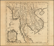
The political map of South and Southeast Asia: the Mughal Empire, Arakan, and Tonkin
The map shows several political entities which are no longer so familiar to the modern eye, namely the Mughal Empire, Arakan, and Tonkin. The Mughal Empire began when Babur (r. 1526-1530), originally from Central Asia, established himself in Kabul, Afghanistan and marched south into India via the Khyber Pass. His descendants consolidated power and fought off rivals. Particularly under the rule of Akbar (r. 1556-1605), the Mughal Empire developed an imperial structure characterized by tolerance of religious differences and a competent administrative elite.
Later in the seventeenth century, the Mughal Empire developed not only as a center of arts and culture—the Taj Mahal was built during this time—but as a political and economic power house. By 1707, under the controversial ruler Aurangzeb (r. 1658-1707), the Mughal Empire reached its largest extent, encompassing much of the Indian subcontinent. A decade later, however, the empire entered into decline. Many of the areas that had been added by Aurangzeb were in open revolt and the dynastic line was in chaos. In 1719, four separate emperors ruled. The Mughal Empire began to lose land and influence, particularly in the face of Maratha opposition and the arrival of the British East India Company.
The kingdom of Arakan, here Aracan, was an Indianized kingdom nestled between the Indian subcontinent, the Bay of Bengal, and what was historically known as Burma. At a significant crossroads in trade routes to India, China, and Southeast Asia, Arakan was diverse religiously and ethnically. Islam came to the region in the eighth century. The Rakhine people migrated to the area around the ninth century; today, the area is Rakhine State in Myanmar. The area was also a site of conflict, with the Burmese and Bengal Sultanate just some of those who sought to control the strategic and economically-important region. Arakan was able to survive and had a formidable navy by the seventeenth century.
However, the Dutch and the Portuguese were also drawn to the trade center. The Dutch arrived in 1623; thirty years later, they completed a treaty that gave the Dutch East India Company duty-free trade rights. However, in 1665 the Mughals smashed the Arakan fleet, forcing the area into decline.
Tonkin (also Tongkin, Tonquin, Tongking) refers to the northern part of what is today Vietnam. It means “eastern capital,” in reference to Hanoi. In the first millennium CE, the area for a time was under the control of China. After 938, however, it was independent and ruled by the Ngô, Đinh, Early Lê, Lý, Trần, and Hồ dynasties. Disputes with China continued, with Lê Lợi as a notable leader who fought the Ming dynasty and established himself in Hanoi in the mid-fifteenth century. By the seventeenth century, Westerners were frequent visitors to the area. They traded with the Trinh lords who were then in power. The French took the area as a protectorate from 1884 to 1945.
Nicholas Sanson (1600-1667) is considered the father of French cartography in its golden age from the mid-seventeenth century to the mid-eighteenth. Over the course of his career he produced over 300 maps; they are known for their clean style and extensive research. Sanson was largely responsible for beginning the shift of cartographic production and excellence from Amsterdam to Paris in the later-seventeenth century.
Sanson was born in Abbeville in Picardy. He made his first map at age twenty, a wall map of ancient Gaul. Upon moving to Paris, he gained the attention of Cardinal Richelieu, who made an introduction of Sanson to King Louis XIII. This led to Sanson's tutoring of the king and the granting of the title ingenieur-geographe du roi.
His success can be chalked up to his geographic and research skills, but also to his partnership with Pierre Mariette. Early in his career, Sanson worked primarily with the publisher Melchior Tavernier. Mariette purchased Tavernier’s business in 1644. Sanson worked with Mariette until 1657, when the latter died. Mariette’s son, also Pierre, helped to publish the Cartes générales de toutes les parties du monde (1658), Sanson' atlas and the first French world atlas.
![[Mumbai] Plan De Bombay et ses Environs](https://storage.googleapis.com/raremaps/img/small/75975.jpg)
![[Untitled Map of Southeast Asia & The Philippines]](https://storage.googleapis.com/raremaps/img/small/47007.jpg)