|
||

|

|
|

|
An extraordinarily rare chart of the Sumatran coast by an American captain in the Pepper Trade, considerably extended in manuscript by a near contemporary.
Background
The Americans broke into the Sumatra pepper trade with the voyage of the Rajah, which returned to Salem in 1797 with a cargo that yielded a stupendous 700 percent profit. Over the course of nearly seven decades the trade became hugely successful and contributed significantly to Salem’s status as the wealthiest city per capita in the country.
The Sumatran pepper ports and adjacent coast remained poorly understood until the 1830s, when Salem shipmasters Charles Endicott (1793-1863) and James Gillis (1798-1835) published two groundbreaking charts. In 1833 Endicott issued his chart of the West Coast of Sumatra from Analaboo to Sinkel along with a book of sailing directions. The following year Gillis complemented Endicott’s work by issuing Sailing Directions for the Pepper Ports of the West Coast of Sumatra, north of Analaboo to Accompany a Chart of the Coast:
“New and Important Chart.
“WILL be published immediately by J. M. Ives, a CHART of the Pepper Ports, on the West Coast of Sumatra, North of Analaboo, by JAMES D. GILLIS, on a scale 30 inches to a degree, with a book of Directions. This Chart, with Capt. C. M. Endicott’s (published in 1832) of the Pepper Ports South of Analaboo, makes the survey of these ports complete.-No survey has heretofore been made of this part of the Coast.” (Salem Gazette, vol. XII, no. 86 (Oct. 28, 1834), p. 4)
Inexplicably, when actually published Gillis’s Chart of the West Coast of Sumatra between Rigas and Diah covered only half of the promised coastline, omitting the stretch between Analaboo and Rigas.
A composite chart of the coast from Analaboo to Diah
Offered here is the 1838 second edition of Gillis’ chart, with pasted-on additions in an unknown hand extending the coverage southeast to Analaboo (modern-day Meulaboh). This chart thus “makes the survey of these ports complete” as promised in the Salem Gazette advertisement.
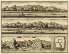
Gillis’ printed chart depicts the stretch of coast running northeast from the great bay at Rigas (now “Pulau Peugaseh”) to another bay just beyond the town of Diah (This entire area shown is in Aceh Province, Indonesia, which suffered so terribly from the 2004 tsunami.) It includes numerous depth soundings, locates navigational hazards, provides profile views of coastal mountains for recognition purposes, and has three inset charts including a large one of Rigas Bay. A long, finely-engraved note describes Gillis’ sophisticated surveying methods, which involved triangulation from a terrestrial baseline and chronometric observations to establish the longitude of at least one control point.
At an early date someone pasted on three sheets of paper to the right and lower margins of the chart, more than tripling its surface area and extending the coverage southeast as far as Analaboo (Note that one corner of the extension has lifted, revealing that the original chart seems to be intact underneath including its full margins.) The new material, entirely in manuscript, includes the coastal outline with towns and rivers, recognition views, large inset charts of Booboon Anchorage and Chellung Bay, and extensive sailing directions.
Gillis died at sea in 1835 and could not have drawn the extension, and the maker’s identity is not known. The backing, a patchwork of western machine-woven fabric and block-printed cloth from southeast Asia, strongly suggests it was executed abroad (If done in Salem the chart would likely have been backed uniformly with canvas or a sheet of heavy paper.) Whoever assembled it did so with the intent of its being used at sea, as there are faint, scattered pencil annotations indicating the track of a vessel.
Rarity
Gillis’ printed chart is extraordinarily rare, with OCLC locating only three examples in aggregate of the first and second editions and no record of its having appeared on the market. I find no indication that the extended chart was ever published.
OCLC #851898158, listing but a single example of the 1838 second edition of the chart held by the Peabody Essex Museum. OCLC #880913957 and 851900140 list examples of the 1834 first edition at Library of Congress and Peabody Essex Museum. Neither Rare Book Hub (formerly Americana Exchange) nor Antique Map Price Record list any example of either edition of the chart having appeared on the antiquarian market.
![[Singapore & Malaca Strait] Carta Esferica Del Mar de China Comprendido Entre La Isla De Borneo y La Peninsula De Malaca, segun os trabajos mas modernos ingelese y holandeses . . . 1864](https://storage.googleapis.com/raremaps/img/small/62184.jpg)