This item has been sold, but you can enter your email address to be notified if another example becomes available.


|
||

|

|
|

|
Stock# 52171
Description
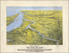
Rare pictorial map of part of the newly created Shenandoah National Park, created by Tom Culverwell in 1935.
Oriented with west at the top, the map illustrates both the recreational points of interest, roads, and other modern features, with historical notes and vignettes interspersed throughout.
Historical vignettes includes:
- Fort Valley -- Where Washington planned to make his last stand if the Americans had lost to the British and lengendary location of the silver mine of Powell the Counterfitter
- 1758 Indian Massacre Site
- Camp Fechner
- Mary's Rock
The location of the glider port at the top left is one of the only references we have ever seen to gliders on a pictorial map.
Culverwell published at least one later map of the Shenandoah Park in 1964.
Reference
Hornsby, Picturing America, p. 165.
![[ Virginia / Maryland / Chesapeake Region ] Pas Kaart van de Zee Kusten van Virginia Tusschen C. Henry ent Hooge Land van Renslaars Hoek. . .](https://storage.googleapis.com/raremaps/img/small/47255.jpg)
![[ The Marks of Sundry of the Chief Men of Virginia ] Aliquot Heroum Virginiae Notae.](https://storage.googleapis.com/raremaps/img/small/98859.jpg)