|
||

|

|
|

|
Stock# 51983
Description
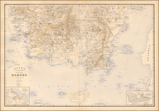
West Java
Attractively color-printed map of Western Java, with a large inset of the Harbor of Batavia and environs, from Stemfoort's Atlas der Nederlandsche bezittingen in Oost-Indië naar de nieuwste bronnen samengesteld en aan de regering opgedragen.
A fine, highly detailed map, with topographical details, place names, and regional borders.
The map is quite rare on the market, this being the first example we have seen.
![[Philippine Islands, Taiwan, etc] Partie des Isles Philippines; Partie de la Chine; Partie de L'Ile Gilolo; Partie de L'Isle Borneo](https://storage.googleapis.com/raremaps/img/small/93579.jpg)
![Asia Secunda Pars Terrae in Forma Pegasi [Asia in the Form of Pegasus]](https://storage.googleapis.com/raremaps/img/small/94173.jpg)
![[Manuscript map of Terra Australis]](https://storage.googleapis.com/raremaps/img/small/92054.jpg)