


|
||

|

|
|

|
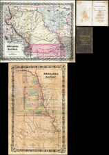
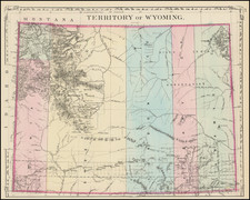
Early separate map of Wyoming, hand colored by counties and and showing only 5 early counties, plus Yellowstone. Early township surveys shown. Shows towns, roads, rivers, lakes, railroads and proposed railroads, Indian Reservations, and a host of other details. The earliest obtainable map of the Territory to appear in a Commercial atlas.
Samuel Augustus Mitchell Jr. inherited the Mitchell Company from his father in 1860. For over thirty years, the company had specialized in the production of school atlases and wall maps of America. They were one of the pioneers on engraving on steel plates. In 1860, Samuel Jr. released the New General Atlas, which had been compiled in house and replaced a previous atlas by Tanner. The elder Mitchell died in 1868 and Samuel Jr. continued the business until the 1890s. At its height, the Mitchell Company employed 250 people and sold 400,000 publications annually.
![[Troops in the Mountains of North America] Nordamericanische Truppen auf einem Gebirgszug](https://storage.googleapis.com/raremaps/img/small/91333.jpg)
![[ Northern Pacific Railroad ] NEW 7-30 GOLD LOAN OF THE Northern Pacific Railroad Co. SECURED BY FIRST MORTGAGE ON RAILROAD AND LAND GRANT. SAFE! PROFITABLE! PERMANENT!](https://storage.googleapis.com/raremaps/img/small/101828.jpg)