


|
||

|

|
|

|
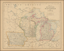
John Farmer's Sectional Map of Michigan -- Re-issued without imprint by Colton.
Fine example of GW & CB Colton's updated map of Michigan, which had first been issued in 1865 (see Rumsey copy below) and revised periodically until 1872.
The present example, dated 1873, would appear to be the first edition of the map which did not include Farmer's name. By 1873, Farmer maps were again being published by Farmer's heirs in Detroit.
As noted by Rumsey:
The [1865 first] issue is unrecorded in Karpinski, who lists editions of 1868, 1870, 1871, and 1872. The base map is the same as the "Map of the Southern Part of Michigan" with the insets changed to a single inset map showing all of Michigan and the Upper Peninsula. There is no copyright date. Many changes from the 1856 issue of the former title.
http://www.davidrumsey.com/luna/servlet/detail/RUMSEY~8~1~237430~5511140:Farmer-s-Sectional-Map-Of-Michigan
G. W. & C. B. Colton was a prominent family firm of mapmakers who were leaders in the American map trade in the nineteenth century. The business was founded by Joseph Hutchins Colton (1800-1893) who bought copyrights to existing maps and oversaw their production. By the 1850s, their output had expanded to include original maps, guidebooks, atlases, and railroad maps. Joseph was succeeded by his sons, George Woolworth (1827-1901) and Charles B. Colton (1831-1916). The firm was renamed G. W. & C. B. Colton as a result. George is thought responsible for their best-known work, the General Atlas, originally published under that title in 1857. In 1898, the brothers merged their business and the firm became Colton, Ohman, & Co., which operated until 1901, when August R. Ohman took on the business alone and dropped the Colton name.
![[ Middle British Colonies Map ] Pensilvania Maryland and Virginia](https://storage.googleapis.com/raremaps/img/small/98228.jpg)
![[ The Old Northwest Territory ] Il Paese De Selvaggi Outagamiani, Mascoutensi Illinesi E parte Delle VI Naxioni](https://storage.googleapis.com/raremaps/img/small/75927.jpg)
![[Carolinas, Virginia, the Chesapeake, Pennsylvania, New York]](https://storage.googleapis.com/raremaps/img/small/71479.jpg)

