
The item illustrated and described below is sold, but we
have another example in stock. To view the example which
is currently being offered for sale, click the
"View Details" button below.


|
||

|

|
|

|
Stock# 51488
Description
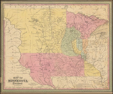
The map is based largely on the works of Nicollet and Pope, and includes extensive notes on early exploration and topography throughout.
An essential map for Minnesota and Dakota collectors. One of the earliest editions of the map, first issued in 1850, the year after Minnesota became a territory.
Massive Pembina and Dacotah counties in the west, with many Indian tribes, forts and early exploration notes shown.

![[Eastern Sheet -- Ohio] Post Road Map of the States of Ohio and Indiana with Adjacent Parts of Pennsylvania Michigan Illinois Kentucky and West Virginia Showing Post Offices With The Intermediate Distances and Mail Routes In Operation On the !st of February 1885 . . .](https://storage.googleapis.com/raremaps/img/small/44153.jpg)
