


|
||

|

|
|

|
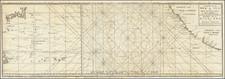
Early Depiction of Chinese Camps and Chinese Laborers in California Gold Country
Detailed map showing a mining land or snow slide on the lands near the Alta Railroad Station (Alta, Placer County, California), just south of the Central Pacific Railroad Company's line.
The location of the slide would appear to be just south of the town of Alta and west of the junction of Canyon Creek and today's Pulp Mill Ditch. The ditches shown likely belong to the Dutch Flat Water Company. The Appendix to the Journals of the California Senate (1860), reports that the Dutch Flat Water Company owned 2 ditches on Cañon Creek on the property of E.L. Bradley & Co.
It is likely that the event depicted here is a either a snow slide in 1866 or a slide in 1880. Based upon the name of the maker of the map, C.E. Uren, we believe it is more likely that the map was created in 1880, as we can find record of Uren working in this area in this general time period.
The 1866 Slides During The Construction of the Central Pacific Railroad
There were a number of slides during the constructio of the Central Pacific Railroad in 1866, which significantly impacted the Chinese laborers working on the railroad.
These slides were described on the Central Pacific Railroad Museum Website as follows:
On December 25, 1866, the Dutch Flat Enquirer reported that "a gang of Chinamen employed by the railroad were covered up by a snow slide and 4 or 5 died before they could be exhumed.... The snow fell to such a depth that one whole camp of Chinamen was covered up during the night and parties were digging them out when our informant left."
A second note for the March 3, 1866 Dutch Flat Enquirer reads:
The C.P.R. Co. have about sixty men, aided by several hundred inches of water, engaged in sluicing out the deep cut just below Gold Run, that was filled up by a huge slide during the late stormy weather. We learn that the Company by adopting this method of removing the obstruction thus occasioned, will not only save much time, but also many thousand dollars. The work along the entire line in this vicinity, both above and below, is progressing finely since the abatement of the storm, and with continued good weather, the days intervening may be numbered as few, when we shall be aroused from our morning slumbers by the shrill whistle of the "iron horse" and the cry of "all aboard for Colfax, Auburn and Sacramento."
A third note from the April 21, 1866 edition reads:
LAND SLIDE.-A huge land slide occurred a few days since near Buckley's ranch, just above this place, on the line of the C. P. Railroad, damaging the ditches of the Dutch Flat Water Company to the amount of several thousand dollars, and rendering a change of the railroad bed necessary, which will also cost an immense sum. Nearly a quarter section, extending along a heavy fill of the railroad several hundred yards, suddenly gave way and moved off in a solid body, taking with it ditches, flumes and everything else that obstructed its course, and making a change from the original survey of the railroad at that point imperative. The material that gave way, it seems, was of a soapy or pipe clay formation, and the pressure from the railroad fill is assigned as the cause.
1880 Slide
It is also possible that the slide referenced occurred in 1880. Both the Scientific American, Volume 42 and the Brotherhood of Locomotive Engineers Monthly Journal, Volume 14, reports a slide above Alta, California as follows:
Recently heavy slides of earth seriously obstructed the track of the Central Pacific Railway above Alta, California. The mass of earth to be removed was so great that by the ordinary methods several weeks would have been required to clear it away. In the emergency hydraulic miners were called upon for help. They brought up their pipes and monitors, constructed a flume from a ditch which was, fortunately, near at hand, and in fourteen hours piped away a body of débris which had been the despair of picks and shovels. The tremendous power of hydraulic mining was thus exhibited in a very practical way. Those who witnessed the swift dispatch of this avalanche of earth have attained, says the Sacramento Union, a lively perception of the effects produced upon the bluffs which contain the gravel deposits. It is, indeed, somewhat singular, the Union continues, that the hydraulic monitor has never been used in making cuts on railroads where the soil is sufficiently soft to be piped. It be thought that in such cases there would be great economy in the application of water power, for a strong head of water directed by an experienced hand will cut out and carry away more dirt in one day than fifty men could shovel and pick in a week.
Map Illustrations
Ilustrated on the map are:
- Steam Engine and railroad cars marked C.P.RR and U.S. Mail
- Two Chinese mining camps
- Illustration of a Chinese worker, leading a horse and cart.
- Several slide areas, one impacting the railroad line just west of the train and a much larger slide area between the two Chinese camps
- Illustrations of a Flume and several water ditches.
- Decorative compass rose (bottom left)
Charles Edward Uren
According to the California State Mining Bureau Bullentin, Charles Edward Uren was a resident of Alameda, California was a Civil Engineer and the owner of the Lightner Mine in Calaveras County and the Superintendent of the Republican and Eagle-Shawmut Mines in Tuolomne County. As a mapmaker, he is perhaps most famous for his wall map of the area around Grass Valley and Nevada City, published by Rand McNally & Co.in 1897.
He was also the father of Lester Charles Uren, who is credited with developing the first curriculum for teaching Petroleum Engineering (UC Berkeley).
![[ Coronado Beach Broadsheet ] Map of Coronado Beach San Diego, California / Coronado Beach and Surrounding Country](https://storage.googleapis.com/raremaps/img/small/99912.jpg)
![[ Lake County Rancho ] Map of the Guenoc County Rancho Finally Confirmed To A.A. Ritchie & P.S. Forbes, Surveyed under the Direction of the U.S. Surveyor General By Wm. Denton Deputy Surveyor. June 1857.](https://storage.googleapis.com/raremaps/img/small/102630.jpg)