|
||

|

|
|

|
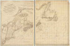
A remarkably detailed chart of the waters around Truro and Provincetown, by one of America's great topographical engineers of the 19th century.
This mammoth chart is based on extensive surveys conducted by the Topographical Engineers in 1833-35, "to aid in the projection of the works for the military defenses of the important harbor formed by the peculiar spiral termination of [Cape Cod], and also to aid our ships of war and other vessels in entering it with safety after making this prominent headland." (Report, p. 3) Printed on four unjoined sheets, the chart provides a wealth of hydrographic data and a surprising amount of terrestrial information. It is vastly more detailed and accurate than any earlier chart of the area, including 18th-century charts published by J.F.W. Des Barres, Matthew Clark and John Norman, as well as a little-known 19th-century chart (ca. 1813) by Salem navigator Samuel Lambert.
Graham was a man who took his responsibilities seriously. In the course of the survey, his team used their theodolite to triangulate 150 points on land and 606 on water, registered 769 high tides (and 692 low tides), and dropped their lead lines to take 13,119 soundings.
With its wealth of detail about depths and marine hazards, the chart is most useful to mariners attempting to negotiate these dangerous waters unscathed. Graham provides textual notes on sea bottom characteristics, wave activity ("heavy breakers"), and topographical features visible from sea. He also offers interesting glimpses into life on terra firma by identifying saltworks, windmills (to work the pumps of the saltworks), marshes where people could gather hay for their livestock and the wharves of Provincetown-the major locus of economic activity at the tip of Cape Cod.
In 1841 the Boston Marine Insurance Company published a one-sheet edition of Graham's chart, now found on the market with some frequency. This four-sheet edition is however quite scarce, especially in such excellent condition as the present example.
James Duncan Graham (1799-1865) graduated from West Point in 1817 and served as an artillery officer for many years. In 1829 he joined the Topographical Engineers, the Army unit responsible for engineering surveys and route surveys for military use, though its brief was later expanded to include all Federal civil engineering projects.
The 1833-35 survey of Cape Cod waters was Graham's first major assignment, and over the course of a long and distinguished career he was an important contributor to some of the most important surveys of the time. Though he was involved in hydrographic surveys of waters off Cape Cod, Cape Fear, Charleston, Pensacola and possibly elsewhere, his specialty seems to have been boundary surveys.
"Graham's superiors must have recognized how conscientiously he recorded and collated his measurements, for he would spend most of his career assisting as an astronomer in the accurate geodetic determination of boundaries-demarcating the United States borders with Canada and Mexico, settling territorial disputes between Maine and New York, and giving a second opinion on the siting of the Mason-Dixon Line. He ended his career as superintending engineer in charge of the seawalls in Boston Harbor." (Garver, p. 87)
![[ Bunker Hill ] A Plan of the Action at Bunkers Hill on the 17th of June 1775 between His Majesty's Troops, Under the Command of Major General Howe, and the American Forces . . .](https://storage.googleapis.com/raremaps/img/small/70223.jpg)