


|
||

|

|
|

|
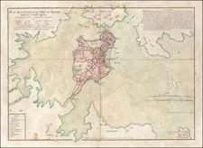
Fine Plan of the Battle of Bunker Hill by Faden
Nice example of William Faden's important Revolutionary War battle plan of the Battle of Bunker Hill, as issued by William Stedman.
Faden's plan of Bunker Hill is one of the earliest and most famous of Faden's battle plans of the American Revolution. The map captures the action in and around the American fortifications at Breed's Hill and Bunker Hill, in what would become the most famous of all early battles of the American Revolution.
Ironically, the plan mixes up the hills; the action took place on the hill closer to Boston, which was Breed’s, but here it labeled at Bunker’s Hill. On top of the mislabeled Bunker Hill is Warren’s Redoubt, named for Dr. Joseph Warren. Warren was shot in the face in the battle, dying there, after he refused a command in favor of fighting amongst his men.
Thomas Hyde Page, an English military engineer who served as aide-de-camp to General Howe during the action, prepared this detailed plan. It is the best known and most commonly reproduced plan of the battle. Originally published by Faden shortly after the battle, this edition of the map appeared in 1793, usually accompanying Stedman's History of the American War.
The plan depicts redoubts, fences, and hedgerows in great detail, as well as troop positions, and the lines of attacking forces. There are detailed placements of British ships and the Copp’s Hill battery (here labeled as Corps Hill) with lines of fire. Charlestown, which was burned in the course of the battle, hugs the southern shore of the peninsula. British troops are shown with a black and white symbol, American troops with a horizontally-striped rectangle. A legend in the lower left explains the major events of the battle as they appear on the base map and the overflap that was supposed to be attached.
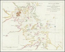
The Battle of Bunker Hill
After the Battles of Lexington and Concord, the American troops were regrouping and organizing. In mid-June, they heard that the British were planning to fortify the hills surrounding the city. Colonial militiamen under Colonel William Prescott built up earthen fortifications on Breed’s Hill on June 16, 1775. These are marked on this map.
Threatened with Americans on the high ground, the British needed to strike the colonial forces. The next day, on June 17, 2,200 troops under British Major General William Howe and Brigadier General Robert Pigot landed on the peninsula, here indicated by the note, “First Landing.” The British burned Charlestown and turned to face the Americans. They marched on Breed’s Hill, but were rebuffed by Prescott’s men. A second assault was also fought off.
On their third attempt, however, the British reached the colonial redoubts and entered into fierce hand-to-hand combat. They forced the Americans to retreat, but at a high cost. The British had over 1,054 casualties in just two hours of fighting, with 200 killed and over 800 wounded. Howe lost every member of his staff. 100 Americans were killed, with 300 wounded.
Although the British won the battle, it was a Pyrrhic victory. They realized that they would not quickly defeat the colonial forces. They also abandoned plans to seize the hills surrounding Boston and, eventually, left the city as well.
William Faden (1749-1836) was the most prominent London mapmaker and publisher of the late-eighteenth and early-nineteenth centuries. His father, William Mackfaden, was a printer who dropped the first part of his last name due to the Jacobite rising of 1745.
Apprenticed to an engraver in the Clothworkers' Company, he was made free of the Company in August of 1771. He entered into a partnership with the family of Thomas Jeffreys, a prolific and well-respected mapmaker who had recently died in 1771. This partnership lasted until 1776.
Also in 1776, Faden joined the Society of Civil Engineers, which later changed its name to the Smeatonian Society of Civil Engineers. The Smeatonians operated as an elite, yet practical, dining club and his membership led Faden to several engineering publications, including canal plans and plans of other new engineering projects.
Faden's star rose during the American Revolution, when he produced popular maps and atlases focused on the American colonies and the battles that raged within them. In 1783, just as the war ended, Faden inherited his father's estate, allowing him to fully control his business and expand it; in the same year he gained the title "Geographer in Ordinary to his Majesty."
Faden also commanded a large stock of British county maps, which made him attractive as a partner to the Ordnance Survey; he published the first Ordnance map in 1801, a map of Kent. The Admiralty also admired his work and acquired some of his plates which were re-issued as official naval charts.
Faden was renowned for his ingenuity as well as his business acumen. In 1796 he was awarded a gold medal by the Society of Arts. With his brother-in-law, the astronomer and painter John Russell, he created the first extant lunar globe.
After retiring in 1823 the lucrative business passed to James Wyld, a former apprentice. He died in Shepperton in 1826, leaving a large estate.
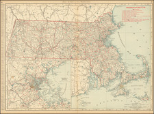
![[ Boston ] The Central Part of Boston, Massachusetts, showing transportation lines of the Boston Elevated Railway](https://storage.googleapis.com/raremaps/img/small/97040.jpg)
