A Very Handsome Example of Laurie & Whittle's Oriental Pilot, with Manuscript Annotations and Sea Tracks, and a Napoleonic War, Single-Family Provenance.
Folio (21 x 15 inches), contemporary full calf, covers with gilt braid border, the whole binding covered in an old loosely-stitched linen cover.
46 engraved maps and one manuscript map, many of which folding (of 47 called for in the Table of Contents, but this example of the atlas issued before the publication of Chart 44 "A New Chart of the Banda Sea", according to a contemporary manuscript note.) Title, contents leaf. The additional manuscript map shows the entrance to the Rio de la Plata and is drawn on the initial blank flyleaf. (Generally very good to very good plus; a few maps with separations at intersecting folds; one map trimmed close to neatline with loss of imprint.)
The present example includes a number of charts which were annotated and show the tracks of voyages undertaken by its original owner during the Napoleonic Wars, as well as an entirely manuscript "Carta Esferica", describing the mouth of the Rio de la Plata, which was almost certainly drawn during MacFarland's transit across the Atlantic to Buenos Aires, which is marked on the chart of the South Atlantic.
The East-India Pilot Publications
Laurie & Whittle's general pilot covering the sea journey to the East Indies (following Sayer & Bennett's before them) was published under several titles, often in the same year, each with a different complement of charts. The usual titles include: The Complete East-India Pilot, or Oriental Navigator, which was typically a larger, two-volume work; The East-India Pilot, or Oriental Navigator, also often quite large -- extending to over 100 charts in some of the 1790s editions; and The Oriental Pilot; Or, East-India Directory, usually a single volume work focusing on the most important charts used for the journey.
The scholarship for all editions of the book is quite incomplete; as far as we are aware, no bibliography provides anything like a comprehensive treatment of the pilots. This is due, in no small part, to the extreme rarity of all volumes from the series.
These atlases were published in a mode that was very different from many late 18th century atlases that were intended for a broad market. Laurie & Whittle's pilots were expensive utilitarian objects. They were intended for use by actual sea captains and navigators who were plotting routes to the East Indies aboard Royal Navy vessels or East Indiamen. Thus buying market was very small, and the damage accrued to the books during use at sea must have been considerable.
Captain James MacFarland
James MacFarland (1769-1852) was probably the first owner and primary user of this atlas. The title page bears his ink stamp, and the book has passed down in has family since his death in 1852.
MacFarland entered the Royal Navy as a First Class Volunteer in 1781. He worked his way through the ranks, serving on Home Stations in the Channel and out of Portsmouth. After 12 years service he was still rated a midshipman on the first of June, 1793. However, his exceptional conduct that day, which would come to be known as The Glorious First of June, aboard Lord Howe's flagship HMS Queen Charlotte (100 guns), would provide the breakthrough in his career. Afterwards, he was promoted to Lieutenant and presented to King George III by Earl Howe as part of his recognition.
Service during the War in the Indian Ocean
MacFarland served aboard HMS Monarch (74 guns), HMS Prince (98 guns), and HMS Lancaster (64 guns) all flagships of Admiral Sir Roger Curtis, at home and on the Cape of Good Hope Station.
On September 12, 1800, while serving in HMS Lancaster, MacFarland received an Official Commendation for a Small Boat Action at Isle de France (Mauritius) in the Indian Ocean. The official account of the ship's log of HMS Lancaster reads:
Port Louis 8 or 9 miles. Quarter past six our boats, viz. The Green Cutter, 1st and 2nd Yawls, under command of Lieutenants MacFarland and Walker (armed with pistols, cutlasses, musquets and pikes, 2 marines and a petty officer in each boat) were sent into harbour of Port Louis to cut out the ship we chased in on the morning under Hambrough colours . About half past seven they got alongside. A heavy musquetry began to fire upon them from the ship. Nothwithstanding which they jumped on board her and after killing a number of their men, took possession of her and cut away her cables and began towing her out, which they had effected under very heavy fire from all the forts. Lieutenant McFarland had his arm broke. . .
In 1802, MacFarland participated in the capture of the Cape of Good Hope. On April 11, 1802, he was appointed in command of HMS Penguin. She was formerly the Dutch ship Komet taken on the Irish Station in 1795 by HMS Unicorn.
MacFarland was given orders to return the Penguin as an independent ship to England, and on April 13th, 1802, they made sale out of Table Bay. The ship arrived at Spithead a year later, on April 23rd, 1803.
Manuscript Annotations and Sea Tracks
Several of the maps in the atlas include manuscript sea tracks, some of them seemingly in different hands, covering journeys in and around the southern Atlantic and Indian Oceans. The first tracks date from 1799, while the latest ones match with MacFarland's return journey to England in 1802-03.
A manuscript note on the back of the map of Madagascar provides an illuminating view of the important geographic and hydrographic information that was gathered by Royal Navy officers. It reads as follows:
Memo: The Location of the Southern Part of the Island of St. Mary is 17° '6 South. There is a Bank lying in 17° 2'3 S Lat: bearing from the SW part of St. Mary S3°4W (True Bearing) Dist: 20 Miles. on Which HMS the Lancaster sounded on the 10th October 1800. The Lattde : of the Road of St. Mary 17° '0 S. Observe that the Chart of Madagascar gives only 2° of Latitude between Foul Point and Fort Dauphin. When the Directory gives 3° 13, The French (by Mr. D'Après's and Mr. Le Gentil's Observations) 3° '7, and Hamilton Moore's Book of Navigation 2° 5'4.
Rarity
The 1799 edition of The Oriental Pilot is essentially unknown; we have found no copies in institutional collections nor in Rare Book Hub nor ABPC. Based on the note on the contents leaf -- suggesting that one map had not yet been issued when the book was published -- it is probable that this is an early, incomplete version of the more common 1800 Oriental Pilot. Laurie & Whittle had issued an edition of The Oriental Pilot in 1797, but none in 1798; it stands to reason that they were in the process of preparing the 1800 edition (or a never-widely-issued 1799 edition) when the special request was made to print this book. Although it is not recorded in our research on MacFarland, based on circumstantial evidence it seems that he deployed to the Cape of Good Hope in 1799, and possibly specially commissioned the book before leaving.
Provenance
Captain James McFarland (with his ink stamp on the title and a few maps);
Thence by descent through the MacFarlane family.
Map List
[Un-numbered manuscript map drawn on the front fly leaf:] CARTA ESTERICA Del Rio de la PLATA Levantada Por las Corbetas de la Marma Rl. Descubierta y Atrevida Ano de 1789 y 1794.

-
Laurie & Whittle. A New Chart of the British Channel. 1794.
-
Laurie & Whittle. A Chart of the Downs. . . 1796.
-
Laurie & Whittle. An Actual Survey of the Coast from Arundel Haven. . . 1794.
-
Laurie & Whittle. Plymouth Sound, Hamoaze and Catwater. Surveyed in 1797. 1798.
-
Laurie & Whittle. A New Chart of the Islands of Scilly. 1794.
-
Laurie & Whittle. A Chart of the Chops of the Channel, to the South of Scilly Islands. . . 1795.
-
Laurie & Whittle. [Northern half:] A New and Correct Chart. . . Exhibiting the WHole of the Atlantic or Western Ocean, and the Greatest Part of the Ethiopic or Southern Ocean. . . 1794.
-
Laurie & Whittle. [Southern half: A New and Correct Chart. . . Exhibiting the WHole of the Atlantic or Western Ocean, and the Greatest Part of the Ethiopic or Southern Ocean. . . 1794.] (Manuscript sea tracks in ink and pencil dating from circa 1799.)
-
Laurie & Whittle. A Chart of the Maderas and Canary Islands. 1794.
-
Laurie & Whittle. The Cape Verde Islands. . . 1794.
-
Laurie & Whittle. Chart of the Açores (Hawks) Islands. . . 1797.
-
A New Chart of the Southern Ocean. (Manuscript sea track in ink and pencil.)
-
Laurie & Whittle. An Hydrographic Survey of False Bay or Bay False. . . 1798.
-
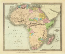
Laurie & Whittle. A New Chart of the Southern Coast of Africa. . . 1794. (Manuscript sea track.)
-
Laurie & Whittle. A Chart of the Inner Passage, between the Coast of Africa and the Isle of Madagascar. 1797.
-
Laurie & Whittle. The Bays of St. Augustin and Tullea, on the Western Coasts of Madagascar, Surveyed in 1755 and 1768. 1794.
-
The Mahe Islands, In the Indian Ocean 180 Leagues to the North East of Madagascar.
-
Plan of Mathurin Bay, on the North Side of the Island of Diego. . .
-
A Chart of the Northern Part of the Indian Ocean. . .
-
A Chart of the Red Sea, from Moka to Geddah.
-
Laurie & Whittle. A Chart of the Gulf of Persia, From Basra to Cape Rosalgate. 1794.
-
Laurie & Whittle. The Coast of India from Point Jigat to Cape Ramas. 1794.
-
Laurie & Whittle. A Plan of Bombay-Harbour, on the Coast of Malabar. . . 1794.
-
Laurie & Whittle. A Chart of the Coast of India, From Goa to Cape Comorin. 1794.
-
Laurie & Whittle. The Coast of India From Mount Dilly to Pondicherry. 1798.
-
Plan of the Bay and Harbour of Trincomalay, on the Island of Ceylon, Surveyed in 1762.
-
Laurie & Whittle. A New Chart of the Gulf or Bay of Bengal with Part of the Indian Ocean. 1797.
-
Laurie & Whittle. The Coast of India between Calymere and Gordeware Points, including The Coast of Coromandel, with Part of the Coast of Golconda. 1794. (Madras highlighted in ink manuscript.)
-
Laurie & Whittle. The Coast of India, from Point Gordeware to the Ganges. . . 1794.
-
Laurie & Whittle. A New Chart of the Braces and Sea Reefs at the Entrance to the Hoogly River. 1794.
-
Laurie & Whittle. A New Chart of the Andaman and Nicobar Islands, and The Adjacent Islands. 1797.
-
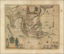
Laurie & Whittle / Jefferys. A Chart of the Straits of Malacca and Sincapore. 1794.
-
Laurie & Whittle. A New Chart of the Oriental Seas and Islands with the Coasts of the Contintent from The Isle of Ceylon to Amoye in China.
-
Laurie & Whittle. A Chart of the South Part of Sumatra and of the Straits of Sunda and Banca. . . 1794.
-
Laurie & Whittle. A New Chart for Sailing Between The Straits of Sunda or Batavia, and the Straits of Banca and Gaspar. 1794.
-
Laurie & Whittle. Sketch of the Straits of Gaspar, By J Huddart, 1788. 1794.
-
Laurie & Whittle. A New Chart of The Java Sea, Within the Isles of Sunda. 1794.
-
Laurie & Whittle. A New Plan of the Straits, Situated to the East of Java & Madura commonly called The Straits of Bali. . . 1794.
-
Laurie & Whittle. A New Chart of The China Sea, with Its Several Entrances. . . 1794.
-
Laurie & Whittle. The Coast of India from Pulo Timon to Pulo Cambir Comprehending The Malayan Coast. 1794.
-
Laurie & Whittle. A Plan of the Bay on The South West Side of Pulo Auore. 1794.
-
Laurie & Whittle. A Plan of the Bay on the South West Side of Pulo Timor. 1794.
-
A Chart of the China Sea, and Philippine Islands, with the Archipelagos of Felicia and Soloo, Shewing the whole Tract comprized, between Canton and Balambangan. . . 1794.
-
Laurie & Whittle. The Harbour of Pta. De Gale, on the West Coast of Ceylon. 1798.
-
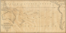
Laurie & Whittle. Laurie & Whittle's New Chart of the Indian and Pacific Oceans Between the Cape of Good Hope, New Holland, and Japan. . . 1797.
-
Laurie & Whittle. A Chart of Van Diemen's Land, The South Extremity of New Holland. . . 1798.
Robert Laurie (ca. 1755-1836) and James Whittle (1757-1818) formed their Fleet Street, London-based firm upon the 1794 death of their employer Robert Sayer, himself one of the dominant print and mapmakers of the last half of the 18th century.
Laurie & Whittle started managing Sayer's business as early as 1787. They took over all managerial duties when Sayer's health flagged in 1792, and they changed the imprint in 1794 upon his death. Sayer left the two a 21-year lease on the shop (at £100 a year) and on Sayer's Bolt Court premises, as well as an option to acquire stock and equipment at a preferential price of £5,000 payable over three years.
Robert Laurie retired from the firm in 1812, and his role was assumed by his son, Richard Holmes Laurie (1777-1858). The younger Laurie worked with James Whittle until the latter died in 1818. After R. H. Laurie died in 1858, Alexander George Findlay, FRGS (1812-1875) purchased the firm from his daughters. The firm continues today under another name, specializing in yachting charts.
Laurie & Whittle were prolific print and map publishers, and throughout their careers, they produced numerous very important and rare works. They carried on Robert Sayer's atlas business and were responsible for editions of The Complete East-India Pilot and The American Atlas.
![[Philippines] Typus Freti Manilensis. Die Straet vande Manilles](https://storage.googleapis.com/raremaps/img/small/85438.jpg)