


|
||

|

|
|

|
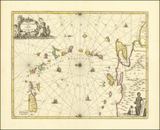
Rare Sea Chart Celebrating Baron de Pointis's Successful Pirate Raid on Cartagena and Subsequent Naval Engagement with the English Navy.
Rare pirate / naval plan of the area between Cartagena and Cuba, showing Baron de Pointis's raid on Cartagena in 1697 and the ensuing naval engagement between Pointis and his band of pirates and the English Navy, sailing in support of their Spanish allies in the region.
Cartagena was one of the richest and best fortified of the Spanish towns in the new world. Cartagena was a major port of the Spanish Main, located near the beginning of the trade route. From its founding in 1538, it was the subject of a number of Pirate attacks, including John Hawkins in 1568, Francis Drake in 1572 and Henry Morgan in 1668. After Morgan, the next major pirate raid on Cartagena was lead by Bernard Desjean, Baron de Pointis, in 1697.
By 1695, the French Navy had declined to the point that it could no longer face the English and Dutch in an open sea battle and therefore had switched to a pirate / guerrilla style of naval warfare. Desperate to raise money to continue the War of the Grand Alliance, France began to look to the New World for legitimate and illegitimate trade opportunities. Bernard Desjean, Baron de Pointis, active in the Caribbean from the beginning of the war, was able to convince King Louis XIV of France to let him try a daring attack on Cartagena in 1697.
Pointis received command of a fleet of seven capital ships, three frigates, and some smaller vessels and was given instructions to proceed in search of galleons and capture such places in the Caribbean as Pointis deemed appropriate. The squadron left from Brest, France, on January 7, 1697, and arrived at Saint-Domingue in the West Indies on March 3rd. Pointis requested assistance from governor Jean du Casse, who gave his support only reluctantly, as he preferred an attack on Portbello. One month later, a fleet with 1,200 soldiers and 650 buccaneers appeared before Cartagena.
The renowned Spanish defences were not what they had once been, and Pointis conquered both fortresses which defended Cartagena relatively easily, losing only sixty men. The French force disembarked on the island of Tierrabomba to attack the Castle San Luis de Bocachica, defended by Don Sancho Ximeno who would repel the attack bravely and then would be betrayed by his own soldiers, mostly black slaves which took the first chance to hand over the weapons and open the castle doors to the French. The French advanced slowly towards the city until seizing the Castle San Felipe from where they bombarded the Puerta de la Media Luna, opened a breach and stormed in seizing Getsemaní after fighting the last defenders of the place. The invaders stayed almost a month in the city, time during which they would rob and sack all the inhabitants and take the religious jewels, failing to fulfill the surrender agreement.
Between May 6th and 24th, the French plundered the city, accumulating loot valued at ten to twenty million livres. Pointis then set sail directly for France, cheating his buccaneer allies of their promised share of the loot. Outraged, the buccaneers returned and plundered the city once more.
On his return voyage to France, Pointis managed to avoid the English admiral John Nevell, whose squadron had been diverted from Cadiz, Spain, to pursue the French privateer. After a three-day chase, Nevell had captured only one ship. Unfortunately for him, this was a hospital ship infested with yellow fever, which now spread through the English and Dutch fleets. The disease killed 1,300 English sailors, six captains, and Admiral Nevell himself; only one captain in the Dutch fleet survived.
The French did not escape unscathed, as yellow fever spread through their fleet, too, killing hundreds of sailors. However, Pointis made it back to France and gave Louis XIV his share of two million livres. He published Relation de l'expédition de Carthagène faite par les François en 1697 in Amsterdam, in 1698.
The text description translates to English as follows:
Naval Encounter between the French Squadron and the English Navy and the route taken by the Baron of Pointis in his Retreat
The dotted line from Cartagena until the first point where it makes an angle shows the route taken by the [French] squadron of the King's ships, in order to catch the wind to reach Cape Tiburon and retreat back to France. From this first point until the second flag where it makes an arc is the route that this same [French] squadron took after being informed that the French Squadron would meet the enemy [English Fleet] at the Cape Tiburon and that it wanted to avoid this encounter by taking the direction of the Bahamas. The two branches of this fork of dotted lines are [first] the right one indicating the way to the Bahamas and [second] the left one indicating the way taken by the French squadron staying with the wind to get ready for battle without coming to close to the enemy.
The third dotted line shown coming close to Jamaica is the route taken by the five [French] vessels after they got separated from the [French] squadron and are in a different order than the ones formed for battle by the [main French] squadron. The dashed line indicated by the head of the six vessels ready for battle indicates the reversed route taken by these vessels to reach the Bahamas, evading the [British] enemy by way of all of these evasive manuevers. The solid line shows the way taken by the [English] enemy in going from Jamaica to Cartagena and the curved solid line until the first boat and straight ahead to the first [D] indicates the wind and pursuit by the nine larger [English] enemy ships to get ahead and block the King's squadron. And those nine English ships noted with a [D] show the situation in which they placed themselves with respect to the French ships that taking advantage of the distance put in between them by the lack of wind at one point and leaving way behind the enemy boats, they went back through the dashed lines as explained above.
The line of the smaller [D]'s shows the shape taken by the [English ] enemy boats to pursue the French squadron when they reversed course. The smaller enemy boats extend from the rear of the King's boats to the head of their nine big boats in order for communication between them to be be kept. And the full line from the first of the big [D]'s until the smaller ones indicate the way followed after they reversed their route like the others, the nine big English vessels that were behind. One can see that the vessels bearing the red flags [the map was unfortunately never colored] designate the enemy army and we only need to take notice that the French vessel that seems surrounded is the "Flute la Ville d'Amsterdam" that was taken prisoner.
To understand under what wind conditions the vessels of both parties were navigating one can use the dotted and solid lines to position one end of a compass on a line and the other end on the wind line parallel to it.
Engraved by Sir le Pautre Architect and regular engraver of the King, with privilege.
Pierre Le Pautre
The engraver "le Pautre," is not identified, but would almost certainly be one of the third generation of Le Pautre architects, artists and engravers, which began its lineage with Adrien Le Pautre. Le Pautre's sons, Jean Le Pautre and Antoine Le Pautre continued in their father's tradition, rising to positions of considerable note in France, but both of whom died well before 1697, when this map was engraved. Among the third generation of Le Pautre's the most probably engraver was Pierre LePautre (1648-1716), son of Jean, who was a well regarded engraver. Antoine's sons, Jean Le Pautre (1648-1735) was a sculptor and Claude Le Pautre (b. 1649) was an architect. Pierre LePautre's son, Pierre II Le Pautre, may also have been the engraver.
Pierre Le Pautre II won the Prix de Rome in 1683, and the following year he went to the Académie de France in Rome, where he was a talented and much praised student. Among his Roman works were two copies after the Antique executed for Louis XIV, the marble groups Faun with a Kid (1685-87; Paris, Louvre) and Meleager (1687-92; on loan to the Hôtel Matignon, Paris). Both demonstrate his early mastery of complex Baroque compositional effects." The LePautres, with the various spellings of their name, were a large family of several generations of architects, sculptors, engravers, designers of ornamental effects. The artists' backgrounds in Rome and in Spain gave them much experience with the ancient and Renaissance sources of the buildings and ornaments of these bold and forceful engravings.
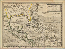
![West Indies. Corrected to 1846 [Bermuda Inset]](https://storage.googleapis.com/raremaps/img/small/94053.jpg)
![West Indies and Central America [Bermuda inset]](https://storage.googleapis.com/raremaps/img/small/89941.jpg)