


|
||

|

|
|

|
Stock# 49894
Description
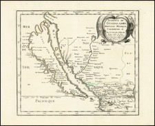
U.S. Mexican Boundary Commission map of Arizona and New Mexico's border with Mexico.
Hand-colored lithographed folding map of the southern part of modern-day Arizona and New Mexico, by one of the great cartographers of the Southwest, John G. Parke.
The map was completed under the direction of Jefferson Davis, then Secretary of War. In that role, Jefferson Davis oversaw many of the most important antebellum Western surveys.
Considerable information is taken from the Emory map, as noted in the description.
Condition Description
Usual toning at folds, with attendant weakening of paper along 112W longitude line.

![[ Mexican Railroads ] Carta De Comunicaciones De Los Estados Unidos Mexicanos Formada de orden de la Secretaria de Estado y del Despacho de Comunicaciones y Obras Publicas, por el Coronel Bodo von Glumer . . . Primera Hoja. 1895 - 1896. (and) Segunda Hoja 1895 - 1896](https://storage.googleapis.com/raremaps/img/small/103235.jpg)
![Mexico [Texas on the Eve of Independence]](https://storage.googleapis.com/raremaps/img/small/84917.jpg)