


|
||

|

|
|

|
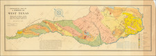
Rare Promotional Map for the Houston & Texas Central Railroad
Large Railroad promotional map of Texas detailing the Houston and Texas Central Railway lines, one of the earliest operating railroads in the state of Texas.
The map was printed shortly after the acquisition of the line by the Southern Pacific Company, in 1883.
The map shows the various operating lines of the H&TC Railway, along with each station along the route.
The map includes an inset railroad map of the United States upper right. Verso printed with tables and advertisements.
Houston & Texas Central Railway
The routes for the H&TC begin with the charter for the Galveston and Red River Railway on March 11, 1848. The company became active until 1852, when it was utilized for a railroad from Houston to the Brazos River and the interior of Texas.
On January 1, 1853, ground was first broken for the G&RR at Houston. Track laying began in early 1856, and the rails reached Cypress City, the twenty-five-mile point, on July 26, 1856. On September 1, 1856, the company was renamed Houston and Texas Central Railway Company. By April 22, 1861, the railroad was open eighty-one miles to Millican, but the Civil War prevented any additional construction until 1867.
The H&TC reached Corsicana in 1871, Dallas in 1872, and Denison in 1873. At Denison connection was made with the Missouri, Kansas and Texas Railroad to form the first all-rail route from Texas to St. Louis and the East.
In 1867, the H&TC acquired the Washington County Railroad, which had completed a line between Hempstead and Brenham in April 1861. This line was extended to Austin, where the final spike was driven on Christmas Day, 1871. The H&TC also acquired the Waco and Northwestern, formerly the Waco Tap, and completed the line between Bremond and Waco in 1872.
Other railroads subsequently merged into the H&TC include the Austin and Northwestern, Central Texas and Northwestern, Fort Worth and New Orleans, Hearne and Brazos Valley, and Houston Railway.
The H&TC was sold to Charles Morgan in March 1877 and came under Southern Pacific control when that company acquired the Morgan interests in 1883. However, it operated under its own name until 1927.
Rarity
The map is very rare. We note only the David Rumsey copy of the 1883 edition (Stanford) and SMU (1882) and the Houston Public Library (1880) list earlier editions. The present example was purchased at auction in December 2016 from Swann Auction Galleries. We note no other examples at auction or in dealer catalogues dating back more than 30 years.
Rand McNally & Co. is a large American map and navigation company best known for its annual atlases. The company got its start in 1856, when William Rand opened a print shop in Chicago. He was joined in 1858 by a new employee, Andrew McNally. Together, the men established their namesake company in 1868. Originally, the company was intended to print the tickets and timetables for the trains running to and through Chicago; their first railway guide was published in 1869.
By 1870, they had shifted from just printing to publishing directories, travel guides, and newspapers. Their first map appeared in 1872 in a railway guide. The map was produced using a new wax engraving method, a cheaper process that gave the company an edge.
By 1880 Rand McNally had entered the education market with globes, wall maps, and geography texts for students. In 1923, Rand McNally published the first Goode’s World Atlas, named after its editor, Dr. J. Paul Goode. For generations afterward, this would be the standard classroom atlas.
In 1899, William Rand left the company, but McNally and his family remained, controlling the company for over a century. In 1904, they published their first road map intended for automobiles and by 1907 were publishing Photo-Auto Guides, which combined photography and mapping to help drivers. In 1924, they produced the Auto Chum, a precursor to their famous road atlases. Rand McNally would remain the leader in road maps and atlases throughout the twentieth century.
In 1937, Rand McNally opened its first store in New York City. Ever on the frontier of technology, Rand McNally pioneered the scribing process for printing tickets in 1958 and printed their first full-color road atlas in 1960. Arthur Robinson developed his now-famous projection of Rand McNally in 1969. By the 1980s, the company was exploring digital reproduction and digital databases of maps for truckers. In the 1990s, they lead the charge to develop trip-planning software and websites. Today, most of its products are available online or in a digital format, including maps for tablets and phones.
![[Printed on Linen] Map of Texas and Loyal Colonies Sometimes Referred To As The United States](https://storage.googleapis.com/raremaps/img/small/93363.jpg)
![[Matagorda Bay] Bahia De S. Bernardo](https://storage.googleapis.com/raremaps/img/small/58540.jpg)
![(Texas and California) The Whig Almanac and United States Register for 1843 [bound with:] The Whig Almanac and Politicians' Register for 1845 [bound with:] The Whig Almanac, and Politicians' Register for 1846 [with maps of Texas and Oregon] [bound with:] The Whig Almanac: 1847.](https://storage.googleapis.com/raremaps/img/small/87041.jpg)
