|
||

|

|
|

|
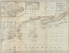
Large Plan of Halifax from the Des Barres's Famed Atlantic Neptune.
Engraved and etched plan of Halifax from the greatest chart book of North America ever made.
The plan is highly detailed, showing the full layout of the streets in Halifax. It also names all of the wharves in the town. Particular importance is given to the fortifications of Halifax, with numerous gun batteries interspersed between wharves. The topography outside the town-proper is particularly well rendered.
The map is one of Des Barres's few town plans, as most of the charts in the Atlantic Neptune focused on broader coastlines.
Halifax during the American Revolution
During the American Revolution, Halifax became the staging point of many attacks on rebel-controlled areas in the Thirteen Colonies and was the city to which British forces from Boston and New York were sent after the over-running of those cities. After the War, tens of thousands of United Empire Loyalists from the American colonies flooded Halifax, and many of their descendants still reside in the city today.
Joseph Frederick Wallet Des Barres (1721-1824) was born in either Paris or Basel, Switzerland, to a Hugueont family. He studied under the great mathematician Daniel Bernoulli at the University of Basel before immigrating to Britain, where he trained at the Royal Military College, Woolwich.
Upon the outbreak of hostilities with France in 1756, he joined the British Royal American Regiment as a military engineer. He came to the attention of General James Wolfe, who was impressed with his charting ability. During this period, he also worked with the legendary future explorer, James Cook, on a monumental chart of the St. Lawrence River.
Des Barres is best known for the Atlantic Neptune, was a remarkable, multi-volume set of sea charts and coastal views prepared from recent surveys, some of which were overseen by Des Barres in Nova Scotia after the Seven Years’ War. The maps, charts, and views were prepared under the supervision of Des Barres and employed as many as twenty engravers and assistants. They were produced over the course of a decade, from 1774 to 1784, in time to be used by the Royal Navy in the American Revolution.
After the Revolution, Loyalists were resettled throughout Canada. As part of this process, a new colony was created by separating Cape Breton from Nova Scotia. Des Barres, who already owned extensive lands in the Maritimes, served as lieutenant governor of Cape Breton Island from 1784 to 1787. He later served as governor of Prince Edward Island from 1804-1812.
Des Barres lived an exceptionally long life, even by today's standards, finally dying at age 102. Des Barres' funeral was held at St. George's Round Church in 1824 and he is buried in Halifax.

![[Route of the 1938 Westward Northwest Passage Cover] Map of the Northwest Territories 1929](https://storage.googleapis.com/raremaps/img/small/60046.jpg)