


|
||

|

|
|

|
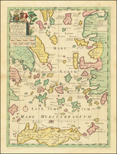
Decorative map of Greece and part of Turkey, including a decorative view of Constantinople, from John Senex's General Atlas.
John Senex's 1720 "Map of Greece with part of Anatolia most Humbly inscrib'd to Alexander Urquhart of Newhall Esq." is a detailed representation of the region extending from Greece and Macedonia to Albania, Bulgaria, and the western part of Asia Minor. It prominently features cities like Constantinople, Scutari, and the Bosphorus Strait, providing a comprehensive view of the land.
The map is marked with symbols that identify a variety of landmarks, from cities and towns to castles and monasteries. The key also pinpoints "places taken from ye Turks", highlighting regions of historical significance. This gives a clear indication of the changeable borders during that period, which was marked by frequent territorial shifts.
One striking feature of the map is the allegorical cartouche, topped by a crescent – the iconic emblem of the Ottoman Empire – and accompanied by two cornucopias, typical symbols of abundance and prosperity.
Greek ruins appear on the right of the cartouche, a simple reminder of the grandeur of ancient Greece. To the left, an Ottoman warrior holds a stock or yoke, towering over a subdued woman, likely representing Europa. This scene symbolizes the Ottoman conquest of Greece and the Balkans over the centuries. The allegory continues with the depiction of a teary cherub next to Europa and an ancient Greek king bound at the far side of the cartouche, his crown dislodged and the head of a statue by his feet. These images further underscore the narrative of subjugation and loss.
John Senex (1678-1740) was one of the foremost mapmakers in England in the early eighteenth century. He was also a surveyor, globemaker, and geographer. As a young man, he was apprenticed to Robert Clavell, a bookseller. He worked with several mapmakers over the course of his career, including Jeremiah Seller and Charles Price. In 1728, Senex was elected as a Fellow of the Royal Society, a rarity for mapmakers. The Fellowship reflects his career-long association as engraver to the Society and publisher of maps by Edmund Halley, among other luminaries. He is best known for his English Atlas (1714), which remained in print until the 1760s. After his death in 1740 his widow, Mary, carried on the business until 1755. Thereafter, his stock was acquired by William Herbert and Robert Sayer (maps) and James Ferguson (globes).
![Asia Minor [Shows Cyprus]](https://storage.googleapis.com/raremaps/img/small/43185.jpg)

![Turkey in Asia [with Cyprus]](https://storage.googleapis.com/raremaps/img/small/59273.jpg)