


|
||

|

|
|

|
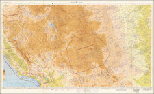
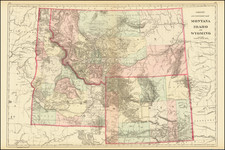
Excellent early map of Idaho, Montana and Wyoming Territories. Wyoming has only 7 counties. Montana has 11 counties. Idaho has 13 counties.
The map shows Indian reservations, mountain ranges, towns, roads, and rivers. One of the most detailed maps of the era.
Samuel Augustus Mitchell Jr. inherited the Mitchell Company from his father in 1860. For over thirty years, the company had specialized in the production of school atlases and wall maps of America. They were one of the pioneers on engraving on steel plates. In 1860, Samuel Jr. released the New General Atlas, which had been compiled in house and replaced a previous atlas by Tanner. The elder Mitchell died in 1868 and Samuel Jr. continued the business until the 1890s. At its height, the Mitchell Company employed 250 people and sold 400,000 publications annually.