![A New Map of Virginia [Chesapeake] By Robert Morden](https://storage.googleapis.com/raremaps/img/small/43053.jpg)


|
||

|

|
|

|
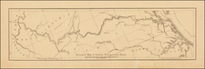
First State of Morden's Map of Virginia.
Fine example of Robert Morden's map of Virginia, one of the earliest obtainable English maps of the Chesapeake region.
Beginning in the 1670s, the English fortunes in North America took a dramatic turn upward, resulting in a booming interest in the British American Colonies and, in turn, the issuance of maps to satisfy this interest. This map appeared in Modern's Geography Rectified, published as early as 1687.
This map is one of the earliest of all English maps to focus solely on the Chesapeake, as earlier maps by Thorton & Greene and Christopher Browne cover substantially broader regions. The map extends from Cape Henry to Cape May and Delaware Bay and Baltimore, extending inland to Stafford County, Kent County and Henrico County. Patomack Falls and Turky Buzhard are noted.
There are 2 states of the map:
- State 1: No page number at top left
- State 2: Page 75 at top left in the printed border
The page number 561 corresponds with the first state of the map.
Robert Morden (d. 1703) was a British map and globe maker. Little is known about his early life, although he was most likely apprenticed to Joseph Moxon. By 1671, Morden was working from the sign of the Atlas on Cornhill, the same address out of which Moxon had previously worked. Most famous for his English county maps, his geography texts, and his wall maps, Morden entered into many partnerships during his career, usually to finance larger publishing projects.
![Notes on the State of Virginia [with the map:] A Map of the country between Albemarle Sound, and Lake Erie, comprehending the whole of Virginia, Maryland, Delaware, and Pensylvania, with parts of several other of the United States of America. Engraved for the Notes on Virginia.](https://storage.googleapis.com/raremaps/img/small/55181.jpg)
![[ The Marks of Sundry of the Chief Men of Virginia ] Aliquot Heroum Virginiae Notae.](https://storage.googleapis.com/raremaps/img/small/98859.jpg)