|
||

|

|
|

|
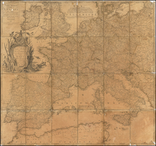
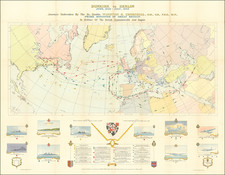
A Map of Hopeful Geopolitical Prophecy -- Nostradamus Map!
Superb hand-colored separately-issued lithographed map of Europe, based on the fanciful predictions of the semi-anonymous "Prophète C. M. ***".
As noted below, we surmise that this map was produced in connection with Felix Deperlas's book on the Prophecies of Nostradamus.
In this map, Europe's borders have been reconfigured to better match the important characteristics of the continent's peoples (at least according to the anonymous prophet C. M.) Here espoused is a theory of geopolitics based on seven variables: ethnography, linguistics, geography, administration, commerce, politics, and morality. While on the face of it, these factors seem as good a place as any on which to build a theory of geopolitics, the resulting map is more self-serving than empirical. Most of the changes foreseen in the map fit well with the French outlook of the 1880s. The map predicted that some empires would fracture along nationalistic and ethnic lines while others would accrete. Interestingly for a French map of the 1880s, the prophet had a very negative opinion of the prospects of the Russian Empire. The following is a list of changes predicted in the map:
- The reconstituted Republic of France (République Française Reconsitutée) has substantially expanded borders to include all of Belgium, Luxembourg, much of South Holland, part of Switzerland, and Alsace-Lorraine.
- The Austro-Hungarian Empire has been balkanized into constituent parts: Bohemia is independent with Prague as its capital; the Hungarian Republic includes Budapest and Vienna; Serbia is substantially expanded and stretches from the Adriatic to the Black Sea; Romania is much larger as well.
- The prophet predicts an unspecified calamity striking England in the year 1885 ("Un grand désastre frappera l'Angleterre en 1885").
- The Republic of Poland has taken over large swathes of Russia and Germany, including the Danzig corridor.
- Russia has been reduced to three separate territories on the outskirts of Europe, namely "Russie" and "Petite Russie".
- The Ottoman Empire has been pushed from Europe and some of their territory on Asia Minor is given over to the Republic of Greece.
Moving the Goal Posts
Like any good prophet whose predictions are disproved by the passage of time, the publisher took the clever step of simply pasting later dates over the ones originally printed on the map. The process took a practically comical twist in the second edition of the map (Dated "Janvier -- 1887 -- Janvier"), which changed none of the geography and simply moved the dates back still further; the great disaster will now strike England in 1887. Even the second edition proved too hasty in its predictions, and in the BnF example, it was again updated with revised-date pastedowns.
Cartographers
The map was likely made in connection with Felix Deperlas's book Les Revelations de la Providence. Les Tremblements de terre de Paris et des principales villes de France en 1885, 1886, 1887 etc. prophetises par Notredame dit Nostradamus, mis en ordre et traduits par Felix Deperlas. Premiere partie. Tremblements de terre
(Translation) The Revelations of Providence. The Earthquakes of Paris and the principal cities of France in 1885, 1886, 1887 etc. Prophetism by Notre Dame or Nostradamus, put in order and translated by Felix Deperlas. First part. Earthquake.
![(Prussian Octopus) En 1788 Mirabeau disait deja: La Guerre est l’industrie Nationale de la Prusse [Already in 1788 Mirabeau was saying: War is the national industry of Prussia]](https://storage.googleapis.com/raremaps/img/small/76554.jpg)