The item illustrated and described below is sold, but we
have another example in stock. To view the example which
is currently being offered for sale, click the
"View Details" button below.


|
||

|

|
|

|
Stock# 48650
Description
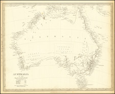
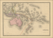
Large detailed map of Australia, showing bays, capes, creeks, islands, lakes, mountains, ports, rivers, shoals, towns, etc.
The Colony of South Australia is separately shown. Populations for New South Wales, Van Dieman's Land, Port Phillip, South Australia, West Australia and North Australia are shown. Stuart's farthest north on Eyre's Creek is shown. The interior is quite unknown.
An excellent early map of Australia.
![[Hunter Island / Tasmania] Carte Trigonometrique des Iles Hunter dressee Par L. Freycinet, Commandant le Casuarina -- December 1802 (Rare Separately Published Example)](https://storage.googleapis.com/raremaps/img/small/53937.jpg)