|
||

|

|
|

|
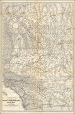
The First Printed Map of the John Muir Trail
First edition of W.B. Wheeler's map of the Sierra Nevada Mountains from the Lone Pine area to Emigrant Lake area, just north of Hetch Hetchy, prepared to accompany W.A. Starr's guide book for the John Muir Trail and the High Sierras.
The map was issued 4 years prior to the completion of the final section of the trail, which took a total of 46 years to complete from the inception of the concept in 1892, and 21 years from the commencement of construction in 1915.
The John Muir Trail is marked in red. Other trail types are marked, with symbols for passes, roads, peaks, glaciers, meadows, hotel - lodges, public camps and ranger stations.
An Index To Trails lists over 100 trails.
Published by the Sierra Club.
History of the John Muir Trail
The idea of the trail along the backbone of the High Sierra originated with Theodore Solomons. He began advocating construction of the trail shortly after the Sierra Club was founded in 1892. John Muir was a founding member and first president of the Sierra Club. Solomons explored the area now known as the Evolution Basin, and traveled extensively throughout the High Sierra, exploring possible trail routes.
Joseph Nisbet LeConte took up the cause in 1898, and the proposed trail was originally called the "High Sierra Trail", although that name was later given to a different trail, running in the east-west direction. LeConte spent years exploring the canyons and passes of the Kings River and Kern River, and climbing peaks along the proposed trail. Along with James S. Hutchinson and Duncan McDuffie, he pioneered a high mountain route in 1908, from Yosemite National Park to Kings Canyon, roughly along the route of the modern JMT. In 28 days, they completed a trip of 228 miles through the high mountains, including several previously unexplored sections.
In 1914, the Sierra Club appointed a committee to cooperate with the State of California to begin construction of the trail. John Muir died later that year, and the proposed trail was renamed in his honor. Construction of the JMT began in 1915, a year after Muir's death, with a $10,000 appropriation from the California legislature. State Engineer Wilbur F. McClure was responsible for selecting the final route. He secured the cooperation of the United States Forest Service, which managed and supervised much of the actual construction. The California state legislature made additional appropriations of $10,000 each in 1917, 1925, 1927 and 1929.
After the Depression began, assistance from the California state government came to an end, and there were still two difficult sections yet to be completed. One was the connection from the Kings River to the Kern River over Forester Pass. The Forester Pass section was completed in 1932, as the result of a joint effort between the Forest Service and the National Park Service. The Forest Service completed the final section at Palisade Creek (in the Palisade Group) in 1938. This section passes by the headwaters of the Middle Fork of the Kings River and over Mather Pass by the "Golden Staircase" to the headwaters of the South Fork of the Kings River. Shortly after, this section was incorporated into newly created Kings Canyon National Park.
The entire project had taken 46 years to complete. William Edward Colby, the first secretary of the Sierra Club, called the finished trail "a most appropriate memorial to John Muir, who spent many of the best years of his life exploring the region which it will make accessible."
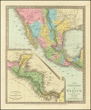
![California [with large inset of Utah and Part of New Mexico]](https://storage.googleapis.com/raremaps/img/small/92004.jpg)