|
||

|

|
|

|
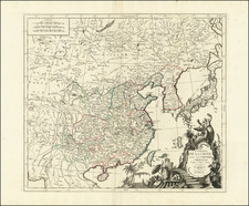
Scarce map of Manchoukuo (Manchuria), published by the Manchoukuo Year Book Co. in Hsinking.
The map covers northern Korea, Manchuria and the contiguous parts of China and the Soviet Union.
The focus of the map is on transit, with Railways, Light Railways, Roads and Air Routes locate.
One other feature of the map is its location of the "Jewish Autoprovince." This is a reference to the Jewish Autonomous Oblast, a federal subject of Russia (an autonomous oblast) in the Russian Far East, bordering Khabarovsk Krai and Amur Oblast in Russia and Heilongjiang province in China. The JAO is Russia's only autonomous oblast and, aside from Israel, the world's only Jewish territory with an official status.
Soviet authorities established the autonomous oblast in 1934, after nearly a decade of trying to create a place for a portion of its Jewish population. It was the result of Soviet nationality policy under Stalin, which provided the Jewish population of the Soviet Union with a territory in which to pursue Yiddish cultural heritage. According to the 1939 population census, 17,695 Jews lived in the region (16% of the total population). The Jewish population peaked in 1948 at around 30,000, about one-quarter of the region's population.
![[ Mount of Olives ] Afbeelding Van Den Olyfberg. Volgens de hedendaagsche Reizigers](https://storage.googleapis.com/raremaps/img/small/101645.jpg)

![(Nuremberg Chronicle) [Geneology of the Tribes of Israel]](https://storage.googleapis.com/raremaps/img/small/98708.jpg)