


|
||

|

|
|

|
Stock# 47362
Description
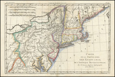
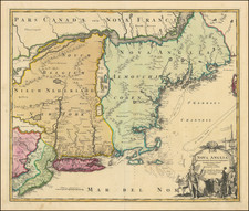
Rare map of Western Territory and the Mid-Atlantic regions of the United States in the last decade of the 18th Century.
The map extends to the Illinois & Wabash Rivers, Lake Michigan and the confluence of the Ohio and Cumberland Rivers in western Kentucky. A number of early towns west of the Ohio are named, including Lexington, Frankfort, Woodford, Danville, Lincoln, Washington, Clarkesville and Louisville in Kentucky. Fort Detroit is shown, as is Kuskusky. Very few settlements west of the Alleghany Mountains.
The map shows all of Michigan and also labels the Chicago River.
The map is from Cooper's Information concerning America, published in Manchester. The work is quite scarce.


![[ Northern Pacific Railroad ] NEW 7-30 GOLD LOAN OF THE Northern Pacific Railroad Co. SECURED BY FIRST MORTGAGE ON RAILROAD AND LAND GRANT. SAFE! PROFITABLE! PERMANENT!](https://storage.googleapis.com/raremaps/img/small/101828.jpg)