|
||

|

|
|

|
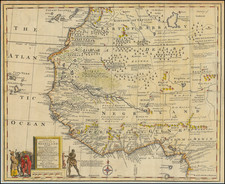
The scramble for Africa elaborated in a detailed sea chart.
Detailed engraved sea chart of the west African coast north from the Cuanza River to Banda Point, covering the entrance to, and some of the course of, the Congo River.
An additional key in Dutch highlights settlements along the coast and separates them into three categories: free territory; disputed territory; decided Portuguese territory.
Interestingly, the territory north of Ambriz, that is now part of Angola, is said to be disputed. This map was produced at a time when Portuguese colonial power in Angola was on the wane; they had suffered a military defeat by Africans at Cassanga in 1862, and elsewhere in the interior in the 1870s. The colonial government did not seek to avenge these losses and largely fell back to the coast.
And on this detail the map underlines an important aspect of the Scramble for Africa -- while European powers were vying for colonial dominance of the continent, their actual territorial control was confined largely to a handful of coastal and riparian settlements.
The chart is based off an original that was published in 1825 and was the product of work by Royal Navy captains W. F. W. Owen and A. T. F. Vidal. This edition is updated to 1863 and would have been perhaps the most authoritative sea chart of the area available in that decade.
Part of the coast of Angola is attributed to Portuguese information: "This part of the Coast from a Portuguese M.S."
![A Chart and Map of the Gold Coast of Guinea from Rio da Costa to Rio da Volta [with a view of Cape Santa Appollonia]](https://storage.googleapis.com/raremaps/img/small/93864.jpg)