|
||

|

|
|

|
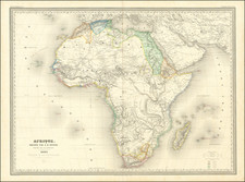
Highly accurate map of equatorial Africa, reflecting the discoveries of Henry M. Stanley and also the still-poor state of African geography even into the last quarter of the 19th century.
The map is very detailed especially along the Congo River, where it is one of the first maps to report much of the geography. Interestingly, the map still reports a large lake in the central Congo basin, which was a centuries-old myth at this point. There is also some conjectural cartography in the north, featuring Liba Lake.
Henry Morton Stanley (1841-1904) was a Welsh journalist and perhaps the foremost explorer of central Africa during the latter part of the 19th century. From 1874 to 1877 he completed his trans-African exploration, starting in the east and finishing in the west (that second part shown on this map). This was his second journey to central Africa, after his first in 1871-72. The primary goal of the expedition was to explore the East African Rift lakes and to explore the Lualaba River downstream towards its outflow.
Stanley wrote about his explorations in his book Through the Dark Continent, published in 1878, which featured this map and others.
Stanley's map is shown in red ink.
There was a companion map to this, titled "Map showing the Eastern Half of Equatorial Africa and the Explorations by Land and Water of Henry M. Stanley In the Years 1874-77."
![[ Ancient World ] Christianographie](https://storage.googleapis.com/raremaps/img/small/80305.jpg)