|
||

|

|
|

|
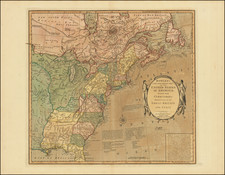
Rare map of the United States, apparently separately issued, based upon Arrowsmith's map of the US in 1795 and Lewis' map of 1796.
The map includes remarkable detail throughout the United States. Tennassee Gouvernement is shown, with lots of detail in the State. Kentucky also receives detailed treatment. East and West Florida are shown, with Georgia extending to the Mississippi. Massive early NW Territory, with extensive annotations. The Connecticut Lands below Lake Erie are shown, as is Detroit and Ft. Joseph.
The treatment of the Mississippi and its Tributaries is outstanding for the time period. Many Indian Tribes are noted. Many early roads are shown throughout the map. Washington and Alexandria are both named.
This is the proto-type map for D.F. Sotzmann's General Map of the United States dated 1804. It is almost certain that Sotzmann's map is drawn from the same plate.
Copies of the 1804 Sotzmann are extremely rare. This earlier variant, without Sotzmann's name but otherwise apparently identical in content can be found in the British Library and Yale map collections, along with the collection of the Pennsylvania Historical collection, but has not appeared in a dealer catalogue or auction for over 30 years.
A gorgeous full color example of this exceptional rarity.

![(French & Indian War) The New Map of the British Dominions in North America; with the Limits of the Government annexed thereto by the late Treaty of Peace, and settled by Proclamation October 7th, 1763 [in:] The Annual Register, or a View of the History, Politicks, and Literature, for the Year 1763. Volume 6](https://storage.googleapis.com/raremaps/img/small/77573.jpg)