|
||

|

|
|

|
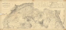
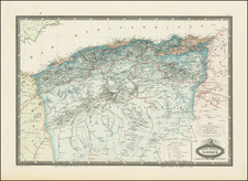
Highly detailed map of parts of South Sudan, southern Sudan, Chad, Democratic Republic of the Congo and the Central African Republic.
The map includes the southern part of the Darfur region of Sudan.
The map was published by the British War Office, Geographical Section and is one of the most detailed and up to date maps of the region published prior to World War II.
Bahr el Ghazal
Bahr el Ghazal was historically subject to raids by the Fur invaders from the neighboring region of Darfur. The khedive of Egypt made Bahr al Ghazal his province in 1864. Powerful native merchants, who set themselves up as princes complete with armies, emerged in the area. The most powerful of them, al-Zubayr, fought and defeated a joint Turkish/Egyptian force sent to Bahr el Ghazal in 1873. The khedive conceded defeat and made Bahr el Ghazal a nominal province of Egypt, with al-Zubayr as its governor. It came under Mahdist control in 1884, when Karam Allāh Muḥammad Kurkusāwī was appointed governor (emir).
The region was visited by the anthropologist Edward Evans-Pritchard in 1929. The region was later incorporated into Anglo-Egyptian Sudan and became the ninth province after being split from Equatoria in 1948, and later a province, and then state, under the Republic of Sudan. In 1996, the region was divided into the four current districts as part of an administrative reorganisation of the country. During the condominium period of joint British-Egyptian rule, the area was administered by British district officers; because of annual flooding and difficult travelling conditions, the area became part of what was known colloquially in the British Sudan Service as "The Bog", with British District Officers known as "Bog Barons" .
![Carte generale de l'Empire romain [des Sarrasins]](https://storage.googleapis.com/raremaps/img/small/82000.jpg)