|
||

|

|
|

|
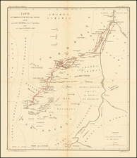
Highly detailed map of part of Sudan and Eritrea.
The map is cetnered on the course of the Nile and locates regions delineated as Blue Nile, White Nile, Khartoum, Kabala, etc.
The map was published by the British War Office, Geographical Section and is one of the most detailed and up to date maps of the region published prior to World War II.
Sudan
In 1899, Britain and Egypt reached an agreement under which Sudan was run by a governor-general appointed by Egypt with British consent. In reality Sudan was effectively administered as a Crown colony. The British were keen to reverse the process, started under Muhammad Ali Pasha, of uniting the Nile Valley under Egyptian leadership, and sought to frustrate all efforts aimed at further uniting the two countries.
During World War II, Sudan was directly involved militarily in the East African Campaign. Formed in 1925, the Sudan Defence Force (SDF) played an active part in responding to the early incursions (occupation by Italian troops of Kassala and other border areas) into the Sudan from Italian East Africa during 1940. In 1942, the SDF also played a part in the invasion of the Italian colony by British and Commonwealth forces. From 1924 until independence in 1956, the British had a policy of running Sudan as two essentially separate territories, the north and south. The last British governor-general was Robert George Howe.
The continued British administration of Sudan fueled an increasingly strident nationalist backlash in Egypt, with Egyptian nationalist leaders determined to force Britain to recognise a single independent union of Egypt and Sudan. With the formal end of Ottoman rule in 1914, Hussein Kamel was declared Sultan of Egypt and Sudan, as was his brother and successor, Fuad I. They continued their insistence of a single Egyptian-Sudanese state even when the Sultanate of Egypt was retitled as the Kingdom of Egypt and Sudan, but the British continued to frustrate such reaches for independence.
The Egyptian revolution of 1952 finally heralded the beginning of the march towards Sudanese independence. Having abolished the monarchy in 1953, Egypt's new leaders, Muhammad Naguib, whose mother was Sudanese, and later Gamal Abdel Nasser, believed the only way to end British domination in Sudan was for Egypt to officially abandon its claims of sovereignty over Sudan. In addition Nasser knew it would be difficult for Egypt to govern the impoverished Sudan after independence.
Eritrea
The boundaries of the present-day Eritrea nation state were established during the Scramble for Africa. In 1869[, the ruling Sultan of Raheita sold lands surrounding the Bay of Assab to the Rubattino Shipping Company. The area served as a coaling station along the shipping lanes introduced by the recently completed Suez Canal. It had long been part of the Ottoman Habesh Eyalet centered in Egypt. The first Italian settlers arrived in 1880.
In the vacuum that followed the 1889 death of Emperor Yohannes II, Gen. Oreste Baratieri occupied the highlands along the Eritrean coast and Italy proclaimed the establishment of the new colony of Italian Eritrea, a colony of the Kingdom of Italy. In the Treaty of Wuchale (It. Uccialli) signed the same year, King Menelik of Shewa, a southern Ethiopian kingdom, recognized the Italian occupation of his rivals' lands of Bogos, Hamasien, Akkele Guzay, and Serae in exchange for guarantees of financial assistance and continuing access to European arms and ammunition. His subsequent victory over his rival kings and enthronement as Emperor Menelek II (r. 1889-1913) made the treaty formally binding upon the entire territory.
In 1922, Benito Mussolini's rise to power in Italy brought profound changes to the colonial government in Italian Eritrea. After il Duce declared the birth of the Italian Empire in May 1936, Italian Eritrea (enlarged with northern Ethiopia's regions) and Italian Somaliland were merged with the just conquered Ethiopia in the new Italian East Africa (Africa Orientale Italiana) administrative territory. This Fascist period was characterized by imperial expansion in the name of a "new Roman Empire". Eritrea was chosen by the Italian government to be the industrial center of Italian East Africa.
![The West Part of Barbary... [on sheet with:] The East Part of Barbary...](https://storage.googleapis.com/raremaps/img/small/94055.jpg)
![[English Language Edition!] Natoliae Quae Olim Asia Minor Nova Descriptio [with] Aegypti Recentior Descriptio [with] Carthageinis Celeberrimi Sinus Typus [shows Cyprus]](https://storage.googleapis.com/raremaps/img/small/78508.jpg)