|
||

|

|
|

|
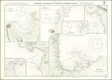
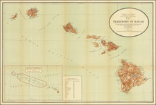
Rare John Lodge edition of Captain James Cook's first map of Hawaii.
The map shows Cook's gracks through the Islands, including dates, topographical features of the islands and a large inset of Karakakooa Bay.
Cook left Hawaii in 1779 having coasted most of the major islands and having done a remarkably accurate job of mapping the islands for a first visit. The great debate regarding this Cook's original map is whether the work was done by Henry Roberts or William Bligh of Mutiny on the Bounty Fame. While the text of the Third Voyage credits Roberts with authorship of the map, the British Hydrographical Office copy of the Official Account includes Bligh's manuscript notes claiming to have constructed the maps.
The present example by John Lodge is a unique adaptation of the the original map in a vertical format. Virtually all other editions show a larger general map with a smaller inset of Karakaooa Bay.
This is the second time we have offered this map for sale in over 20 years.