


|
||

|

|
|

|
The Rare Second State of De L'Isle's "Towering Landmark Along the Path of Western Cartographic Development"
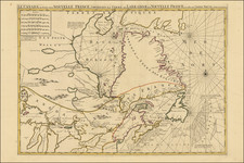
Fine example of the second state of Guillaume De L'Isle's landmark map, the first printed map to accurately depict the course and mouth of the Mississippi River.
Carl Wheat called the map a "towering landmark along the path of Western cartographic development." De L'Isle's map also includes greater accuracy in the Great Lakes region and in its depiction of English settlements along the East Coast. Excellent detail of the Indian villages in East Texas, based upon the reports of d'Iberville and the Spanish missionaries. The best depiction of the Southwest to date, with early trails & Indian tribes. Cumming described the map as "profoundly influential."
De L'Isle's Carte du Mexique . . . is drawn from the reports brought back to France from the survivors of the La Salle expedition into the interior of North America and from information derived from the explorations of Bienville and d'Iberville. In the year preceding the publication of the map, De L'Isle utilized his position with the King of France to gain access to the best available information from the New World. During this time period he assiduously compiled the geographical data from the reports of the French Jesuit Missionaries and Explorers in North America, along with Spanish manuscript maps (often copied by the missionaries while they were acting in the service of the Spanish as spiritual guides and gaining their confidence). The result of this work were a series of landmark maps of North America, including his map of North America ( L'Amerique Septentrionale, 1700), Canada and the Great Lakes ( Carte du Canada ou de la Nouvelle France, 1703), and the Mississippi Valley & Gulf Coast ( Carte de la Louisiane et du Cours du Mississipi 1708).
The present state of the map appeared at an especially key time in history, during the middle of the War of the Spanish Succession (1701-1714), also known as Queen Anne's War in North America. To make a long story short, while France's preferred candidate to assume the contested Spanish throne, Felipe V, ultimately succeeded in gaining power, the French generally suffered reversals at the hands of their perennial nemesis, Britain. The French attack on Charleston, South Carolina (1706) was unsuccessful, although the French successfully seized the entirety of the precious sugar-producing island of St. Christopher. A showdown between the French naval fleet under Admiral Jean du Casse and the English fleet under Admiral John Benbow failed to produce a decisive result. Upon the conclusion of the war, at the Treaty of Utrecht (1713), French losses in Europe compelled Louis XIV to cede both St. Christopher and peninsular Acadia (Nova Scotia) to Britain.
The unfortunate result of the war nevertheless spurred France to redouble its efforts to shore up its position in the Americas. Most notably, the French founded New Orleans, Louisiana, in 1718, and the fortress of Louisbourg on Cape Breton Island (Canada), in 1720. Importantly, the present map would have been a definitive source for French officials when deliberating their plan in the southern colonial regions of North America.
Guillaume de L'Isle (1675-1726) was the Geographer Royal to both Kings Louis XIV and Louis XV. Of a brilliant and precocious mind, while still only in his 20s, De L'Isle established himself as the leading cartographer in France, then the epicenter of mapmaking in Europe. With his unrivaled access to both official French government and Jesuit sources, De L'Isle was able to devise maps of North America which were dramatically more advanced than those of his contemporaries, of which the present map is a prime example.
The states of the map can be identified as follows:
- State 1 bears De L'Isle's first address on 'Rue Des Canettes'
- State 2 includes a later address 'Quai de l'Horloge' and the additional imprint of Louis Renard
- State 3 removes the Renard imprint and adds the engraver's name (Simoneau)
- State 4 includes the name Philippe Buache and the date 1745
- State 5 includes a new title, references the "Etats-Unis" and the date 1783, among other features
One of the most important and influential maps of the region during the early 18th Century.
Guillaume De L'Isle (1675-1726) is probably the greatest figure in French cartography. Having learned geography from his father Claude, by the age of eight or nine he could draw maps to demonstrate ancient history. He studied mathematics and astronomy under Cassini, from whom he received a superb grounding in scientific cartography—the hallmark of his work. His first atlas was published in ca. 1700. In 1702 he was elected a member of the Academie Royale des Sciences and in 1718 he became Premier Geographe du Roi.
De L'Isle's work was important as marking a transition from the maps of the Dutch school, which were highly decorative and artistically-orientated, to a more scientific approach. He reduced the importance given to the decorative elements in maps, and emphasized the scientific base on which they were constructed. His maps of the newly explored parts of the world reflect the most up-to-date information available and did not contain fanciful detail in the absence of solid information. It can be fairly said that he was truly the father of the modern school of cartography at the commercial level.
De L’Isle also played a prominent part in the recalculation of latitude and longitude, based on the most recent celestial observations. His major contribution was in collating and incorporating this latitudinal and longitudinal information in his maps, setting a new standard of accuracy, quickly followed by many of his contemporaries. Guillaume De L’Isle’s work was widely copied by other mapmakers of the period, including Chatelain, Covens & Mortier, and Albrizzi.
![(Carolinas) Virginiae Partis australis, et Floridae partis orientalis, interjacentiumqus regionum Nova Descriptio [A New Description of the Southern Part of Virginia and the Eastern Part of Florida, and the Intervening Regions.]](https://storage.googleapis.com/raremaps/img/small/94131.jpg)
![Charte von Den Vereinigten Staaten von Nord-America nebst Louisiana . . . 1805 [Rare 1st State of Gussefeld's Louisiana Purchase Map]](https://storage.googleapis.com/raremaps/img/small/63496.jpg)
![[Acapulco] Haven van Aquapulco in t' Coninkryk van Nova Spagnien in de Zuyd Zee](https://storage.googleapis.com/raremaps/img/small/91246.jpg)