|
||

|

|
|

|
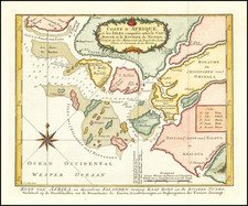
A rare sea chart from one of the great nautical atlases of the Dutch Golden Age of cartography: De Zee-Atlas Ofte Water-Weereld.
The map captures the west African coast from the Gambia River in the north (here called R. Portugues) to roughly Cape St. Francis in South Africa. The African kingdoms or regions of Mandinga, Melli, Melegette, Greincust, Quaquaas, Goutcust, Benin, Gabon, Loango, Angola, Mataman, and Cimbebas are labelled. The mouth of the Congo River is shown as a wide and open body of water with scattered islands, overall much larger than the actual width of the river.
Although we would not expect to see great detail of Africa's interior topography on a sea chart, the map is reflective of a long era in which the inland features of the continent had not been reliably reported to European cartographers.
The information on this map was invaluable to the Dutch East India trade, as it informed the journeys of their ships to and from the East Indies. The ships mostly stayed well away from the coast until reaching the Cape Colony or the Netherlands on the return journey, but nonetheless it was important information in the the event that a landing was required.
Pieter Goos (1616-1675) was an important Dutch mapmaker of the Golden Age -- his particular specialty was sea charts and atlases, such as the present map. Goos had inherited the business from his father Abraham Goos (1590-1643), who had excelled in the field in the first half of the 17th century.
Pieter Goos (ca. 1616-1675) was a Dutch map and chart maker, whose father, Abraham Goos (approx. 1590-1643), had already published numerous globes, land and sea maps together with Jodocus Hondius and Johannes Janssonius in Antwerp. Pieter gained recognition due to the publication of sea charts. He bought the copperplates of the famous guide book for sailors, De Lichtende Columne ofte Zeespiegel (Amsterdam 1644, 1649, 1650), from Anthonie Jacobsz. Goos published his own editions of this work in various languages, while adding his own maps. In 1666, he published his De Zee-Atlas ofte Water-Wereld, which is considered one of the best sea atlases of its time. Goos' sea charts came to dominate the Dutch market until the 1670s, when the Van Keulen family came to prominence.
![Egypt and Barca [with] Abissina and Nubia [with] Congo. Angola. Cafres. Monoemugi. Monomotapa. Zanguebar & Madagascar](https://storage.googleapis.com/raremaps/img/small/78890.jpg)
![[Southern Africa] Kaart van het Zuidelykste Gedeelte van Afrika of het Land der Hottentotten](https://storage.googleapis.com/raremaps/img/small/89739.jpg)