|
||

|

|
|

|
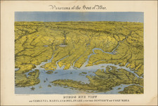
One of the Earliest Obtainable Civil War Maps
Rare separately published Civil War map of the area between the Occoquan River and Rockville, Maryland, published in Washington D.C. by V.P. Corbett. The present map is the second state of five, all of which are extremely rare.
This is one of the earliest Battle Maps issued during the Civil War, one of the most detailed and one of the rarest.
The map focuses on the area between the Potomac River and Bull Run, including all of Fairfax County, Virginia and parts of Loudon and Prince William Counties, as well as much of Montgomery County in Maryland and the District of Columbia. Washington is shown in plan view, with its ring of Union camps and fortifications given in some detail, as are the Confederate entrenchments around Fairfax Courthouse. Union and Confederate positions are shown schematically for the Battle of Bull Run.
Some of the positions noted around Bull Run include:
- General Beauregard's Main Army
- General Johnson's Advance
- Position of General McDowell's Army on July 21st
- Richardson's Column
- The Rebel Cavalry Charge across Bull Run
Between Bull Run and Washington, a number of Rebel Blockades, occupied areas, "Trees Felled" and other positions are noted, including Lt Tompkins Cavalry Chart near Fairfax Courthouse
Virgil Corbett
Born in Corbettsville, New York, Corbett moved to Washington, D.C. and then to Arlington. He held several patens (a "sleeping garment for travelers" and a "potato harvester") and in the 1870s won at least two elections for Treasurer of Alexandria County, but was a Union Sympathizer.
Washington, Monday, Sept. 16[, 1861] . Mr. V.P. CORBETT, of this city, made a reconnaissance near Munson's Hill [in Falls Church]. He went so close to the rebel works that he was discovered and chased by the rebels. In order to effect his escape, he was obliged to abandon his horse and take to a piece of thick woods, into which the rebel cavalry could not penetrate." (The New York Times, Sept. 17, 1861)
Early in 1861 Corbett also published Sketch of the SEAT OF WAR In Alexandria & Fairfax Cos. (Stephenson #522). Corbett would later publish a map with a very similar title, Map of the Seat of War, Showing the Battles of July 18th, 21st, & Oct. 21st, 1861, with E.R. McKean, which included inset maps of Inset map: Leesburg to Harpers Ferry and Map from the mouth of Occoquan River to Richmond.
Rarity
The map is extremely rare on the market. While the later October 1861 edition has appeared several times in recent years, this is the only example of the July 1861 map we have seen offered on the market.
![[ Virginia Natives ] Fictilium Vasorum In Quibus Cibum Coquunt Forma XV [Their Seething of Their Meat in Earthen Pots]](https://storage.googleapis.com/raremaps/img/small/98700.jpg)
![[ The Marks of Sundry of the Chief Men of Virginia ] Aliquot Heroum Virginiae Notae.](https://storage.googleapis.com/raremaps/img/small/98859.jpg)