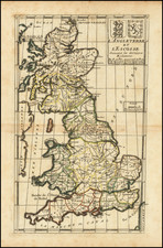
|
||

|

|
|

|
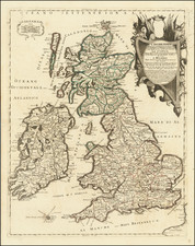
With Portraits of William & Mary
Rare map of the British Isles, published in Amsterdam in 1690.
The title is flanked by portraits of William III and his wife Mary, against a background of the accoutrements of war. The map may well have been prepared shortly after William & Mary's accension to the English throne in 1689, when Anglo-Dutch ties were particularly close.
The coats of armes above the portraits is still a Stuart coat of arms, with an eleborate anagram of W and M, and the figures of Neptune and his attendants at the bottom of the title.
To the left, a sunlit orb is encircled by the garter, with supporters representing the four continents. Two vignettes of naval engagements are engraved in the lower part of the map.
Carel (Carol) Allard (Allardt) (1648–1709) was an engraver and publisher based in Amsterdam. Part of a prominent family of Dutch mapmakers, publishers, and print sellers, his father was engraver and publisher Hugo Allard (1627–1684), who left his business to Carel upon his death. Carel published anything in demand, including maps, topography, ethnography, newsprints, and restrikes of old plates of artistic prints, many of which likely came from his father’s stock. In 1706, Carel gave his copperplates to his son Abraham Allard, before going bankrupt.
![[WWI British Propaganda Map in Italian] L’impero Britannico in Guerra](https://storage.googleapis.com/raremaps/img/small/86441.jpg)
![[Jamestown, Saint Helena] Plan de la Forteresse et Bourg, De L'Isle De St. Helene](https://storage.googleapis.com/raremaps/img/small/77017.jpg)