|
||

|

|
|

|
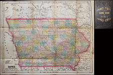
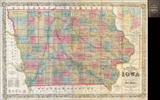
A Stunning Early Map of Iowa
Fine early map of Iowa during its initial period of rapid settlement, showing the land office locations, a table of population by county in 1840 and 1850, and the settled areas of adjoining states.
Rare first edition--shows Wahkaw County at the confluence of the Sioux and Missouri Rivers.
Bright and beautifully colored, this impressive early map of Iowa shows counties in alternating colors, with ranges and townships delineated. The map shows the dense settlement that had occurred in eastern Iowa by the middle of the nineteenth century, especially along the Mississippi River.
The map reflects the sparsely developed western portion of the state. Indicative of the way in which farmlands were sectioned and sold, the counties throughout the state retain a relatively uniform size and shape.
The map also features river systems, railroads, common roads, towns, and topographical features. Large sections of Missouri, Illinois, and Wisconsin are included.
A list of Land Offices is posted at left.