
The item illustrated and described below is sold, but we
have another example in stock. To view the example which
is currently being offered for sale, click the
"View Details" button below.


|
||

|

|
|

|
Stock# 46002
Description
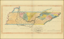
Fine example of Matthew Carey's map of Tennessee from the 1814 edtion of Matthew Carey's General Atlas, the first appearance of hand coloring in an American Atlas.
One of the earliest obtainable maps of Tennessee to include counties, with still only a small number shown.
Massive Cherokees region. Only 12 Counties shown, Sullivan, Washington, Greene, Sevier, Jefferson, Blount, Knox, Hawkins, Tennessee, Davidson, Sumner and the massive Cherokee region. Shows early roads, towns, Indian Lines, rivers, mountains, Powell's Valley, Forts, etc.
Matthew Carey issued the first American published Atlas in 1795, which was subsequently updated in 1796, 1800 and again in 1814, with the 1814 being the first obtainable in original color.
![[Alabama, Mississippi, Arkansas, Louisiana and part of Tennessee and Western Florida] Amer. Sep. No. 56 Partie des États Unis](https://storage.googleapis.com/raremaps/img/small/93538.jpg)


![Charte von Den Vereinigten Staaten von Nord-America nebst Louisiana . . . 1805 [Rare 1st State of Gussefeld's Louisiana Purchase Map]](https://storage.googleapis.com/raremaps/img/small/63496.jpg)
![Carte De La Louisiane Et Du Cours Du Mississipi . . . Juin 1718 [1st State!]](https://storage.googleapis.com/raremaps/img/small/59797.jpg)
