|
||

|

|
|

|
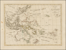
Rare Sea Chart of Australia, Southeast Asia, and the Indian Ocean from the Dutch Golden Age of Cartography
Early pair of sea charts of the Indian Ocean and contiguous regions. Australia is remarkably delineated for this early date and reflects recent Dutch encounters with the continent.
These charts were first published by Hendrick Doncker in his De Zee-Atlas ofte Water-Werelt (Amsterdam, 1669). They are rarely seen on the market today.
These charts show the Indian Ocean, together stretching from the eastern half of Africa to Australia (Hollandia Nova) and part of Japan (Iapan) in the northeast corner. Although there are some minor issues with the shape of islands like Borneo and Sri Lanka (Ceylon) and the orientation of Madagascar and Japan (Iapan), the landforms are easily recognizable and remarkably accurate for their time.
As these charts were intended for nautical use, they are most concerned with coasts and islands, and the inland areas are not cluttered with information irrelevant to mariners. The coastal land is quite detailed, though, with many labels indicating natural features along with settlements and larger, regional names. There are a few areas, notably around Australia and New Guinea, where the coasts were not fully known to Europeans and are therefore left unfinished.
Rhumb lines criss-cross the pages, meeting at various central points around the charts, and several of these central points are adorned with compass roses. On each compass rose, a fleur-de-lis points north while a Christian cross points east, indicating the position of Jerusalem in relation to Europe.
In addition, each chart has a beautiful strapwork. The cartouche on the western chart is decorated with snakes and other reptiles, along with a large bat at the top. By contrast, the cartouche on the eastern chart is adorned with shells and sea plants.
The Dutch Golden Age and Australia
In the late 1500s, seven Dutch provinces in the northern Netherlands achieved independence from Spain and formed the Dutch Republic. Though the Dutch state was small and ruled by a decentralized system of control, it managed to cultivate a powerful seventeenth-century sea empire based on trade. This era became known as the Dutch Golden Age. These two charts illustrate the Dutch sphere of influence at this time in Southeast Asia and, particularly, their early exploration of Australia.
On these charts, readers may find details of the multiple Dutch encounters with Australia, which was then called New Holland. In 1616, Dirck Hartog traveled around the Cape of Good Hope (El Cabo de bona Esperanca) and toward Java, but his ship was carried too far east and landed at an island just off the shore of Australia. Though he only stayed for a few days before continuing on to the Philippines, Hartog left a plaque on the end of the island which became a landmark for future explorers. On this map, the area where Hartog landed can be found on the western coast of Australia, just below the Tropic of Capricorn (Tropicus Capricorni).
Another significant Dutch explorer who traveled to Australia was Pieter Nuyts. In 1626-1627 Nuyts sailed nearly 1,000 miles along the southern coast of Australia, mapping it for the Dutch East India Company. This expedition is noted on the chart, near another note discussing the slightly earlier (1622) voyage of a ship called the Leeuwin.
Some of the most important Dutch voyages to Australia were those of Abel Tasman. Though Tasman’s first voyage traced a large circuit around Australia and New Guinea and explored both present-day Tasmania and New Zealand, only evidence of his second voyage in 1644 can be found on this map. This second voyage explored the northern coast of Australia, and readers can find locations named after Tasman himself as well as van Diemen, the governor of the Dutch East Indies who sent Tasman on his travels.
Other expeditions and explorers such as Houtman (1619), Carstenszoon (1623), and de Wits (1628) are also referenced on the map with notes and place names. These references demonstrate the profound reach and influence of the Dutch Empire in Asia and Oceania, and the chart’s impressive accuracy highlights the quality of Dutch cartography during this period.
Dutch sea atlases in the Golden Age
Due in large part to their powerful trade empire, the Dutch became known for cartography in the seventeenth century. Their publishing houses produced the highest quality work in Europe, particularly those maps and charts of foreign lands, and Dutch map-making set the bar for cartographic accuracy and artistry into the early-eighteenth century.
An important subset of this business was maritime cartography, which was pioneered by Gerard Mercator when he published his famous world map in 1569. Before Mercator’s projection, navigators used a combination of rutters (written sailing directions, often including a coastal profile) for coastal sailing and portolan charts for long-distance ocean travel. However, Mercator’s map was innovative because it included vertical meridians along with rhumb lines, which have a constant bearing relative to true north. This allowed for accurate navigation even with no land in sight.
Mercator’s projection was not immediately accepted by Dutch navigators, as sailors needed special training in order to calculate distances using the chart. Yet despite its slow start, the new Mercator projection eventually revolutionized navigational charts, allowing sailors to travel long distances more easily and precisely.
Another innovator in the creation of Dutch sea atlases was Lucas Janszoon Waghenaer, who published his Spieghel der zeevaerdt in 1584, the first book of sailing directions that directly incorporated charts. This kind of pilot book became so associated with Waghenaer that it was known as a waggoner. Waghenaer’s book was original and popular among navigators due to its drawings of coastal profiles, which allowed the sailor to compare the coast he saw with that of the sketch. Particular attention was paid to inlets and clear landmarks, such as windmills or castles. Waghenaer’s charts also contained what became standardized symbols, which gave the sailor additional information such as locations of rocks, buoys, and places to anchor.
Waghenaer’s Spieghel was translated into a number of languages, including French, Latin, German, and Portuguese. He later published two successive pilot books, altering the size of his charts for easier use at sea and improving the accuracy and extent of his previous work. His work had great influence on later Dutch maritime cartography, and his second pilot book was a model for Willem Janszoon Blaeu’s Het Licht der Zeevaert (1608).
The growing production of Dutch sea atlases in the seventeenth century led to increasingly impressive work among prominent cartographers of the day, including Blaeu and Hessel Gerritsz. Blaeu was particularly prolific, though he faced fierce competition from contemporaries. Blaeu’s copperplate engravings were used by cartographers all through the seventeenth century, speaking to their outstanding quality.
Sea atlas printing in the second half of the seventeenth century was controlled by the Lootsman brothers, Pieter Goos, and Doncker, the creator of this chart. Doncker’s charts in particular were seen as high quality. They were original in subject matter (for example, charting the coasts of Africa and Brazil), and his constant and careful revision meant his work was usually up-to-date.
Tracking this chart’s revisions
These charts are relatively close approximations of an equally rare pair of charts by Johannes van Loon, first published in 1661, and by Jacob and Casper Theunis Jacobsz in about 1666. The latter took the name Lootsman (sea pilot) to avoid confusion with another Amsterdam publisher of the name Jacobsz.
Both the Van Loon and Jacobsz (Lootsman) charts are in turn based on an earlier set of sea charts first published by Hendrick Doncker in 1660, although the present charts are now oriented such that the map extends a bit further south and west.
While Doncker’ first and second charts appear similar in an initial viewing, a closer comparison shows that Doncker has in fact made major updates throughout this example, most notably:
- Australia: The southwestern coastline has been revised.
- Java and nearby islands: The shape of Java is revised and the islands to the east significantly updated.
- Borneo: The shape of Borneo is significantly revised.
- Philippines: The islands are significantly revised, most notably Mindanao and Luconia (Luzon).
- Taiwan: The shape of the island is significantly revised.
- South China Sea: The shape of Hainan and the coastline of northern Vietnam is significantly altered.
- Cambodia/South Vietnam: Cambodia is now named, and the coastal features altered.
- Siam: The river system has been removed.
- Malacca/Sumatra: The shape and contour are significantly revised.
- Ceylon: Significantly reduced size and shape revised.
- Bengal/East Indian Coastline: Completely revised coastline.
- West Indian Coastline: Orientation revised.
- Gujarat Coastline: Significantly revised and islands removed.
- Gulf of Oman/Yemen: Coastal shape revised and re-oriented.
- Persian Gulf: Shape and coastal features heavily revised.
- Red Sea: Coastal shape and orientation revised.
- Madagascar: Shape and orientation revised.
- Mozambique Coastline: Heavily revised.
The beauty and precision of these charts make Doncker’s cartographic skill clear. These charts are very rare on the market and are fine examples of Dutch Golden Age hydrography.
Hendrik Doncker was a prominent bookseller in Amsterdam best known for his sea charts and nautical atlases. He issued his own original charts, which he updated frequently, and also worked with colleagues like Pieter Goos, for example to produce the pilot guide, De Zeespeigel. He died in 1699, after fifty years in business. His plates then passed to Johannes van Keulen.
![[Gansu & Ningxia] Kansu](https://storage.googleapis.com/raremaps/img/small/61498.jpg)
![[Puducherry-- Hand Drawn Map] Plan de la Ville de Pondichery. Legende des Rues de la ville blanche et de la ville noire de Pondichery avec les numeros d'ordre correspondant a ceux du plan que Mr. le Gouvernor a approuve le Mai 1856](https://storage.googleapis.com/raremaps/img/small/58607.jpg)
![[ Taprobana / Sri Lanka ] Duodecima Asie Tabula](https://storage.googleapis.com/raremaps/img/small/101258.jpg)