


|
||

|

|
|

|
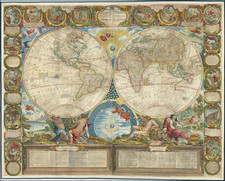
A very fine example of the Jean-Baptiste Crepy version of Jean Baptiste Nolin's rare and decorative wall map of the World.
The quality of the engraving and the artistic virtuosity of the composition are especially fine. The world is displayed in double hemispheres amidst a pageant of Baroque allegory. Four atlas figures, representing the four seasons, lift the earthly hemispheres into the heavens. In the space below the intersection of the hemispheres, is an allegorical depiction of the Ptolemaic conception of the universe, while above the radiant Sun at the center of the Copernican system appears in finely engraved splendor. The panel above the map contains roundels depicting seminal Biblical scenes, located on either side of the fine title cartouche.
Geographically, the map beautifully reflects contemporary conventions, featuring both the knowledge gained from recent discoveries, as well as prevailing cartographic misconceptions. With respect to the depiction of North America the eastern regions represent the best knowledge of French and English cartographers, including the delineation of the Mississippi and its tributaries based on the discoveries of the Sieur de La Salle and Louis Joliet.
The portrayal of the American West is fascinating. California is no longer shown to be an island, having recently been proven to be a peninsula, following the 1701 expedition of Padre Eusebio Kino. However, the map features a splendid depiction of the mythical Strait of Anian that was though to run from the Pacific Northwest to the top of Hudson Bay, so connecting the Atlantic and Pacific Oceans. Moreover, the 'Mare de l'Ouest', or Great Western Sea, located in northern California is shown to be connected to a river system whose headwaters have proximity to the Mississippi basin, so holding out the promise of another navigable transcontinental route. It would be almost another century before these misconceptions were definitely disproved. The Pacific Ocean is traversed by the tracks of the great circumnavigators, including Ferdinand Magellan and Olivier van Noort.
The depiction of Asia is generally quite progressive, although one will notice that the Caspian Sea still appears the ovoid form it assumed until the 1730s. In East Asia, Korea is shown to be a peninsula, while in Japan the area of Hokkaido is shown to be part of mainland Siberia.
In Oceania, the western half of Australia is well delineated, while the eastern regions are shown to be an almost complete enigma, and erroneously connected to New Guinea. Abel Tasman's isolated discoveries in southern Tasmania and New Zealand from his voyage of 1642-3 are depicted, although the latter is shown to be connected to the mysterious 'Terres Australes', the rumored great southern continent.
The present map is an especially fine example of the grand genre of wall, or parlor, maps that enjoyed an iconic place in 17th and early 18th-century Europe. Large, highly decorative and expensive productions, they were considered to be the ultimate signs of wealth and intellectual sophistication. In this vein, such wall maps appeared prominently in works of fine art, most notably the paintings of Johannes Vermeer. Displayed in the salons of leading merchants and noblemen, the maps were especially prone to damage and their survival rate is extremely low. The present map is truly exceptional, for it is preserved in remarkably fine condition.
Jean Baptiste Nolin (c.1657-1708) was the leading French cartographer of the late sixteenth-century. Fulfilling various royal commissions for Louis XIV, Nolin had privileged access to official French geographical sources. He notably maintained a close and highly lucrative association with the great Venetian cartographer Vincenzo Maria Coronelli. Nolin's wall maps of the World and the continents are all exceedingly rare, and are considered to be his finest achievements.
The present example represents a later state of the map, first issued in 1700.
Jean-Baptiste Nolin (ca. 1657-1708) was a French engraver who worked at the turn of the eighteenth century. Initially trained by Francois de Poilly, his artistic skills caught the eye of Vincenzo Coronelli when the latter was working in France. Coronelli encouraged the young Nolin to engrave his own maps, which he began to do.
Whereas Nolin was a skilled engraver, he was not an original geographer. He also had a flair for business, adopting monikers like the Geographer to the Duke of Orelans and Engerver to King XIV. He, like many of his contemporaries, borrowed liberally from existing maps. In Nolin’s case, he depended especially on the works of Coronelli and Jean-Nicholas de Tralage, the Sieur de Tillemon. This practice eventually caught Nolin in one of the largest geography scandals of the eighteenth century.
In 1700, Nolin published a large world map which was seen by Claude Delisle, father of the premier mapmaker of his age, Guillaume Delisle. Claude recognized Nolin’s map as being based in part on his son’s work. Guillaume had been working on a manuscript globe for Louis Boucherat, the chancellor of France, with exclusive information about the shape of California and the mouth of the Mississippi River. This information was printed on Nolin’s map. The court ruled in the Delisles’ favor after six years. Nolin had to stop producing that map, but he continued to make others.
Calling Nolin a plagiarist is unfair, as he was engaged in a practice that practically every geographer adopted at the time. Sources were few and copyright laws weak or nonexistent. Nolin’s maps are engraved with considerable skill and are aesthetically engaging.
Nolin’s son, also Jean-Baptiste (1686-1762), continued his father’s business.

![[The centre of this Slider is to be placed by a Thread or Pin over the centre of the respective Planisphere for any Operation]](https://storage.googleapis.com/raremaps/img/small/65557.jpg)